 All Countries


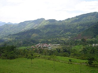
Buenavista, Colombia
Boyacá · Colombia
Buenavista is a small town in Boyacá, Colombia with a population of 0. Elevation: 6,965 ft (2,123 m). Average temperature: 64°F (18°C).
Data updated June 2026
Discover Buenavista, Colombia
Explore over 40 sections covering people, economy, housing, health, crime, climate, community, costs, trends, schools, colleges, hospitals, treatment centers, industries, museums, libraries, breweries, farmers markets, grocery stores, pharmacies, campgrounds, parks, trails, stadiums, ski resorts, daycare centers, nursing homes, churches, fire stations, cell towers, bridges, power plants, EV stations, prisons, radio stations, airports, police stations, post offices, Amtrak stations, superfund sites, UNESCO sites, and more.
Use the tabs and dropdown menus below to navigate every data point we track for this city.
About Buenavista
Maripí är en ort i Colombia. Den ligger i departementet Boyacá, i den centrala delen av landet, 100 km norr om huvudstaden Bogotá. Maripí ligger 1 199 meter över havet och antalet invånare är 1 143.
People
Climate
| Population Density | 0 / sq mi |
| Elevation | 6,965 ft (2,123 m) |
| Coordinates | 5.5138°, -73.9491° |
| Timezone | America/Bogota |
| Country | 🇨🇴 Colombia |
| State / Province | Boyacá |
| Average Temperature | 64°F (18°C) |
| January Average | 63°F (17°C) |
| July Average | 64°F (18°C) |
| Annual Precipitation | 280.0 inches (7,113 mm) |
| Annual Snowfall | 0.0 inches (0 cm) |
About Buenavista
Buenavista is a small town in Colombia (Boyacá) with a population of 0. The city sits at an elevation of 6,965 feet (2,123 meters) above sea level. The average annual temperature is 64°F (18°C). Temperatures range from 63°F in January to 64°F in July. Annual precipitation averages 280.0 inches. The timezone is America/Bogota.
Temperature
| Annual Average | 64.0°F |
| 19% above Colombia avg | |
| January Average | 63°F (17°C) |
| July Average | 64°F (18°C) |
| Sunny Days | 344 days/yr |
Geography
| Elevation | 6,965 ft (2,123 m) |
| Area | 44.8 sq mi (115.9 km²) |
| Population Density | 0/sq mi |
| Coordinates | 5.5138°N, 73.9491°W |
| Timezone | America/Bogota |
Precipitation & Snow
Air Quality
Nearby Volcanoes
4 volcanoes within 200 km. Closest: Bravo, Cerro (156 km).
| Name | Type | Elevation | Last Eruption | Distance |
| Bravo, Cerro | Stratovolcano | 3,985 m (13,074 ft) | 1720 | 156 km |
| Ruiz, Nevado del | Stratovolcano | 5,279 m (17,320 ft) | 2020 | 167 km |
| Santa Isabel | Shield | 4,944 m (16,220 ft) | -850 | 175 km |
| Tolima, Nevado del | Stratovolcano | 5,215 m (17,110 ft) | 1943 | 180 km |
Monthly Weather
| Month | Avg Temperature | Precipitation | Summary |
|---|---|---|---|
| January | 63°F (17°C) | 2.6 in | Coldest, Driest |
| February | 64°F (18°C) | 3.6 in | |
| March | 65°F (18°C) | 5.4 in | Warmest |
| April | 65°F (18°C) | 8.0 in | |
| May | 65°F (18°C) | 7.6 in | |
| June | 64°F (18°C) | 5.4 in | |
| July | 64°F (18°C) | 3.5 in | |
| August | 64°F (18°C) | 4.1 in | |
| September | 64°F (18°C) | 6.1 in | |
| October | 63°F (17°C) | 8.9 in | Wettest |
| November | 64°F (18°C) | 7.0 in | |
| December | 63°F (17°C) | 4.0 in |
Buenavista has a seasonal temperature swing of 2°F / from 63°F in January to 65°F in March. Total annual precipitation is 66.2 inches, with October being the wettest month (8.9") and January the driest (2.6").
Schools in Buenavista
21 public schools (NCES 2022-23 data).
| School | Level | Enrollment | Teachers | Student/Teacher |
|---|---|---|---|---|
| Escuela la honda | — | — | — | — |
| Escuela de Campohermoso | — | — | — | — |
| Escuela de Pismal | — | — | — | — |
| Escuela de Corrales | — | — | — | — |
| Escuela Santa Rosa | — | — | — | — |
| Escuela Santa Helena | — | — | — | — |
| domingito | — | — | — | — |
| Escuela de San Miguel | — | — | — | — |
| Escuela Naranjitos | — | — | — | — |
| escuela de patiño | — | — | — | — |
| Escuela de Domingito | — | — | — | — |
| Sade Sabaneta | — | — | — | — |
| Escuela de concepcion | — | — | — | — |
| escuela de San Pedro | — | — | — | — |
| Escuela de Sabaneta | — | — | — | — |
| Escuela El Toro | — | — | — | — |
| I.E JMSS Sede la Laja | — | — | — | — |
| I.E. Jose Maria Silva Salazar - Sede Principal | — | — | — | — |
| Escuela Portachuelo | — | — | — | — |
| Escuela La Honda | — | — | — | — |
| Escuela de San Pedro | — | — | — | — |
Radio Stations near Buenavista
5 stations within ~55 km.
| Station | Genre | Quality | |
|---|---|---|---|
| W Radio | — | AAC+ 32 kbps | |
| Olímpica Stereo - Barranquilla | — | AAC+ 64 kbps | |
| Olímpica Stereo(Bogotá) | — | AAC+ 64 kbps | |
| Blu Radio - Musica | 2000s, 80s | MP3 96 kbps | |
| Toca Stereo 105.3 fm | — | AAC+ 96 kbps |
Museums in Buenavista
| Name | Type | Address | Phone | Annual Revenue |
|---|---|---|---|---|
| Palacio de la Cultura |
Libraries in Buenavista
| Name | Address | Staff | Annual Visits | Circulation | Collection | Programs |
|---|---|---|---|---|---|---|
| Biblioteca municipal | 0.0 | |||||
| Biblioteca Municipal | 0.0 | |||||
| Biblioteca municipal de Coper | 0.0 | |||||
| Biblioteca Pública Municipal "Jairo Elberto González Castillo" | 0.0 |
Farmers Markets in Buenavista
| Name | Address | Season | Hours | Organic | Website |
|---|---|---|---|---|---|
| Centro de Acopio y Mercadeo | |||||
| Plaza de Ferias Ganaderas | |||||
| Plaza de La Papa La Carupana | |||||
| Plaza de Mercado | |||||
| Plaza de mercado | |||||
| Plaza de Mercado | |||||
| Plaza de mercado | |||||
| Plaza de Mercado |
Breweries in Buenavista
| Name | Type | Address | Phone | Website |
|---|---|---|---|---|
| D |
Stadiums & Teams in Buenavista
| Team | League | Division |
|---|---|---|
Airports Near Buenavista
11 airports within the area.
| Airport | IATA | Type |
|---|---|---|
| German Olano Air Base | PAL | Medium Airport |
| Tunja Airport | — | Medium Airport |
| Barbosa Airport | — | Small Airport |
| Furatena Airport | — | Small Airport |
| Guaymaral Airport | — | Small Airport |
| La Esperanza Airport | — | Small Airport |
| La Libélula Airport | — | Small Airport |
| Muzo Airport | — | Small Airport |
| Puerto Nare Airport | NAR | Small Airport |
| Puerto Perales Airport | — | Small Airport |
| Velásquez Airport | PYA | Small Airport |
Quick Facts
🇨🇴 About Colombia
Public Holidays in Colombia
18 public holidays this year
Download Full City Report
Get a comprehensive, print-ready PDF with all data for Buenavista.
Get ReportFrequently Asked Questions About Buenavista
What is the weather like in Buenavista?
Buenavista enjoys a temperate climate with an average annual temperature of 64°F (18°C). Winter temperatures average 63°F in January, while summers reach an average of 64°F in July. The area receives 344 sunny days per year, well above the national average of 205. Annual rainfall totals 280.0 inches.