 All Countries


Chóra Sfakíon, Greece
Crete · Greece
Chóra Sfakíon is a small town in Crete, Greece with a population of 243. Elevation: 75 ft (23 m). Average temperature: 54°F (12°C).
Data updated June 2026
Discover Chóra Sfakíon, Greece
Explore over 40 sections covering people, economy, housing, health, crime, climate, community, costs, trends, schools, colleges, hospitals, treatment centers, industries, museums, libraries, breweries, farmers markets, grocery stores, pharmacies, campgrounds, parks, trails, stadiums, ski resorts, daycare centers, nursing homes, churches, fire stations, cell towers, bridges, power plants, EV stations, prisons, radio stations, airports, police stations, post offices, Amtrak stations, superfund sites, UNESCO sites, and more.
Use the tabs and dropdown menus below to navigate every data point we track for this city.
About Chóra Sfakíon
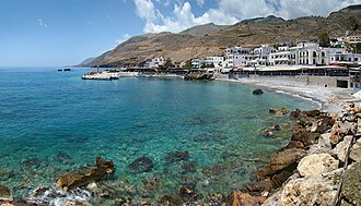
Hóra Sfakíon or simply Sfakia is a small town on the south coast of Crete, Greece. It is the capital of the remote and mountainous region of Sfakiá, and has just 322 inhabitants. It lies on the south coast near the end of the Imbros Gorge, 74 km south of Chania. It has two small harbours, where the ferry boats from Agia Roumeli dock, which in the summer bring the hikers from the Samaria Gorge to ride buses back to the northern coast. From Hóra Sfakíon, ferries also sail to the nearby coastal village of Loutro and Gavdos island.
People
Economy
C+Climate
| Population | 243 |
| Population Density | 1 / sq mi |
| Elevation | 75 ft (23 m) |
| Coordinates | 35.2018°, 24.1371° |
| Timezone | Europe/Athens |
| Country | 🇬🇷 Greece |
| State / Province | Crete |
| Average Temperature | 54°F (12°C) |
| January Average | 40°F (4°C) |
| July Average | 68°F (20°C) |
| Annual Precipitation | 35.6 inches (904 mm) |
| Annual Snowfall | 0.0 inches (0 cm) |
| Median Household Income | $21,060 |
About Chóra Sfakíon
Chóra Sfakíon is a small town in Greece (Crete) with a population of 243. The city sits at an elevation of 75 feet (23 meters) above sea level. The average annual temperature is 54°F (12°C). Temperatures range from 40°F in January to 68°F in July. Annual precipitation averages 35.6 inches. The timezone is Europe/Athens.
Income: Chóra Sfakíon vs Greece
Commute Mode
Income
| Median HH Income | $21,060 |
| 72% below Greece avg |
Employment & Poverty
| Establishments (County) | 14 |
Business (County)
Tax & Cost of Living
Commute & Transportation
Walkability
Climate in Chóra Sfakíon
Chóra Sfakíon has an average annual temperature of 18.6°C (65°F). The hottest month is Jul (26.7°C), the coldest is Feb (11.3°C). Average annual precipitation is 639 mm.
Temperature
| Annual Average | 53.5°F |
| 1% below Greece avg | |
| January Average | 40°F (4°C) |
| July Average | 68°F (20°C) |
| Sunny Days | 271 days/yr |
Geography
| Elevation | 75 ft (23 m) |
| Area | 259.2 sq mi (671.4 km²) |
| Population Density | 1/sq mi |
| Coordinates | 35.2018°N, 24.1371°W |
| Timezone | Europe/Athens |
Precipitation & Snow
Air Quality
Tsunami History
6 tsunamis recorded within 500 km. Highest wave on record: 8.6 m (28 ft).
| Year | Location | Cause | Max Wave | Deaths | Distance |
| 1866 | S. COASTS PELOPONNESUS, GREECE | Earthquake | 8.6 m | — | 136 km |
| 2013 | CRETE | Earthquake | 0.0 m | — | 120 km |
| 2013 | CRETE | Earthquake | 0.0 m | — | 88 km |
| 1629 | CRETE | Earthquake | — | — | 118 km |
| 1494 | ISLAND OF CRETE | Earthquake | — | — | 128 km |
| 365 | CRETE | Earthquake | — | 5,000 | 106 km |
Nearby Volcanoes
2 volcanoes within 200 km. Closest: Milos (169 km).
| Name | Type | Elevation | Last Eruption | Distance |
| Milos | Stratovolcano(es) | 751 m (2,464 ft) | 140 | 169 km |
| Santorini | Shield(s) | 367 m (1,204 ft) | 1950 | 175 km |
Monthly Weather
| Month | Avg Temperature | Precipitation | Summary |
|---|---|---|---|
| January | 40°F (4°C) | 7.0 in | Coldest, Wettest |
| February | 40°F (4°C) | 5.6 in | |
| March | 43°F (6°C) | 4.4 in | |
| April | 49°F (10°C) | 2.2 in | |
| May | 57°F (14°C) | 1.1 in | |
| June | 65°F (18°C) | 0.5 in | |
| July | 68°F (20°C) | 0.3 in | Warmest |
| August | 68°F (20°C) | 0.2 in | Driest |
| September | 63°F (17°C) | 0.9 in | |
| October | 56°F (13°C) | 3.6 in | |
| November | 49°F (9°C) | 4.1 in | |
| December | 43°F (6°C) | 5.8 in |
Chóra Sfakíon has a seasonal temperature swing of 29°F / from 40°F in January to 68°F in July. Total annual precipitation is 35.6 inches, with January being the wettest month (7.0") and August the driest (0.2").
Radio Stations near Chóra Sfakíon
46 stations within ~55 km.
| Station | Genre | Quality | |
|---|---|---|---|
| Μουσικό Κανάλι Ρεθύμνου 101.3 | greek folk | MP3 192 kbps | |
| Uncut GR | — | MP3 | |
| Κρητικόραμα 93.8 | greek traditional | MP3 128 kbps | |
| Zarpa Χανιά | greek, news | MP3 96 kbps | |
| Gavdos 88.8 | greek folk music | MP3 128 kbps | |
| Erotokritos 87.9 fm | — | MP3 128 kbps | |
| Αντέννα Δυτικής Κρήτης 97.1 | news, news talk | MP3 128 kbps | |
| Κραχ | greek music | MP3 128 kbps | |
| Gavdos 88.8FM | — | MP3 128 kbps | |
| Παλαιόχωρα 89.3 | pop | MP3 128 kbps | |
| Koinoniko Radiofono Xaniwn | jazz, politics | MP3 128 kbps | |
| Κρήτη 98.9 | greek traditional | MP3 128 kbps | |
| Δρόμος 105.4 | greek music | MP3 128 kbps | |
| Μαρτυρία 95.5 | orthodox christian, religion | MP3 128 kbps | |
| Ράδιο Μαρτυρία 95.5 | byzantine, ecclesia | MP3 128 kbps | |
| Ασύρματος 1134 | greek folk | MP3 96 kbps | |
| Δίκτυο 91.5 | folk, greek | MP3 128 kbps | |
| Αντέννα Δυτικής Κρήτης | news, pop | MP3 128 kbps | |
| Ρυθμός 97.4 | greek, mainstream | MP3 128 kbps | |
| Φάρος 91.8 | greek, traditional | MP3 128 kbps | |
| Laiko 107 | greek folk music | MP3 | |
| EROTOKRITOS | — | MP3 128 kbps | |
| Μεγαλόνησος 89.8 | greek, traditional | MP3 128 kbps | |
| Άστρο 96.4 | folk, greek | MP3 64 kbps | |
| Ραδιοκύματα 102.6 | folk, pop | MP3 128 kbps | |
| Studio Ρέθυμνο 980 | folk, greek | MP3 192 kbps | |
| Παραπολιτικά Ρεθύμνου 102.4 | music, news | MP3 128 kbps | |
| Fly 95.9 | greek, mainstream | MP3 128 kbps | |
| Ένταση 93.5 | — | MP3 320 kbps | |
| rebetiko sealabs | — | MP3 40 kbps | |
| Adelin 107.3 | greek folk music | MP3 128 kbps | |
| Ριζίτες 92.4 | greek traditional | MP3 128 kbps | |
| Δίκτυο FM 91.5 | — | MP3 128 kbps | |
| Venus 91 | greek, mainstream | MP3 128 kbps | |
| Chania Rock FM 96.8 | rock | MP3 128 kbps | |
| Amore 87.5 | folk, greek | MP3 128 kbps | |
| Fresh 105 | mainstream, pop music | AAC+ 96 kbps | |
| Radio Sfakia | — | MP3 128 kbps | |
| FLY 92.3 (US) | — | AAC 128 kbps | |
| D-Code 96,2 | 70s, 80s | MP3 192 kbps | |
| Original 94.4 | mainstream, pop | MP3 128 kbps | |
| Team 102 | news talk, pop | MP3 128 kbps | |
| Mix FM GR | greek folk | MP3 | |
| D-code 96.2 | electronica, house | MP3 192 kbps | |
| 104.4 Fm Radio | various | MP3 128 kbps | |
| Chania 99.6 | mainstream, pop | MP3 128 kbps |
Museums in Chóra Sfakíon
| Name | Type | Address | Phone | Annual Revenue |
|---|---|---|---|---|
| Ancient Olive Oil Mill | ||||
| Askyfou War Museum | ||||
| Folklore Museum of Gavalochori | ||||
| House of Stone Creations | ||||
| Man and rock | ||||
| Man and Samaria | ||||
| Museum - Headquarter of the 1905 rebellion in Therisso | ||||
| Museum Monastery Foinikias | ||||
| National Resistance Museum | ||||
| Olive and Oil Museum | ||||
| Roustika Manor | ||||
| Stone Museum | ||||
| The Cretan Runner Museum | ||||
| μουσείο εθνογραφικό |
Hotels in Chóra Sfakíon
39 hotels within city radius — OpenStreetMap data
Cafes in Chóra Sfakíon
11 cafes within city radius — OpenStreetMap data
Castles in Chóra Sfakíon
19 castles within city radius — OpenStreetMap data
Dentists in Chóra Sfakíon
1 dentists within city radius — OpenStreetMap data
Gas Stations in Chóra Sfakíon
4 gas stations within city radius — OpenStreetMap data
Airports Near Chóra Sfakíon
3 airports within the area.
| Airport | IATA | Type |
|---|---|---|
| Chania International Airport | CHQ | Large Airport |
| Maleme Air Base | — | Small Airport |
| Tympaki Air Base | — | Small Airport |
Post Offices in Chóra Sfakíon
1 post offices.
| Post Office | Address |
|---|---|
| Ελληνικά Ταχυδρομεια Hellenic Post |
Churches & Religious Organizations in Chóra Sfakíon
28 religious organizations (IRS tax-exempt data).
| Name | Address |
|---|---|
| Aghios Pavlos | |
| Agios Charalambos | |
| Agios Dimitrios | |
| Agios Eleftherios | |
| Agios Konstantinos & Agia Eleni | |
| Agios Nikitas | |
| Agios Spyridonas | |
| Agios Theotoko | |
| Agos Atanasios | |
| Chapel of Saint Anthony | |
| Chapel of the 12 apostels | |
| Church Agios Nikolaos | |
| Church of Archangel Michael | |
| Prophet Elias | |
| Sotiros Christou church | |
| Timios Stavros | |
| Timios Stavros | |
| Αγία Αικατερίνη | |
| Αγία Βαρβάρα | |
| Άγιος Βασίλειος |
Quick Facts
🇬🇷 About Greece
Public Holidays in Greece
15 public holidays this year
Download Full City Report
Get a comprehensive, print-ready PDF with all data for Chóra Sfakíon.
Get ReportFrequently Asked Questions About Chóra Sfakíon
What is the population of Chóra Sfakíon?
Chóra Sfakíon has a population of 243 residents and is located in Greece. The population density is 1 people per square mile, spread across 259.2 square miles.
Is Chóra Sfakíon expensive to live in?
The median household income is $21,060, 72% below the national average of $75,149.
What is the weather like in Chóra Sfakíon?
Chóra Sfakíon has a four-season climate with an average annual temperature of 54°F (12°C). Winter temperatures average 40°F in January, while summers reach an average of 68°F in July. The area receives 271 sunny days per year, well above the national average of 205. Annual rainfall totals 35.6 inches.
How is the job market in Chóra Sfakíon?
There are 14 business establishments in the area.