Cireșa, Romania
Caraș-Severin County · Romania
Cireșa is a small town in Caraș-Severin County, Romania with a population of 207. Elevation: 955 ft (291 m). Average temperature: 46°F (8°C).
Population source: Wikidata (dated census and official estimates), GeoNames. Climate: WorldClim 2.1 normals (1970-2000), NASA POWER. Updated August 2026
Discover Cireșa, Romania
Explore over 40 sections covering people, economy, housing, health, crime, climate, community, costs, trends, schools, colleges, hospitals, treatment centers, industries, museums, libraries, breweries, farmers markets, grocery stores, pharmacies, campgrounds, parks, trails, stadiums, ski resorts, daycare centers, nursing homes, churches, fire stations, cell towers, bridges, power plants, EV stations, prisons, radio stations, airports, police stations, post offices, Amtrak stations, superfund sites, UNESCO sites, and more.
Use the tabs and dropdown menus below to navigate every data point we track for this city.
About Cireșa
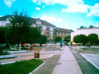
Oțelu Roșu is a town in northeastern Caraș-Severin County, Romania, in the Bistra Valley. It is situated on the national road 68, between Caransebeș and Hațeg. The town administers two villages, Cireșa (Bisztracseres) and Mal (Mál). It is situated in the historical region of Banat.
People
Climate
| Population | 207 |
| Population Density | 8 / sq mi |
| Elevation | 955 ft (291 m) |
| Coordinates | 45.5258°, 22.3884° |
| Timezone | Europe/Bucharest |
| Country | 🇷🇴 Romania |
| State / Province | Caraș-Severin County |
| Average Temperature | 46°F (8°C) |
| January Average | 28°F (-2°C) |
| July Average | 64°F (18°C) |
| Annual Precipitation | 30.6 inches (776 mm) |
| Annual Snowfall | 5.3 inches (13 cm) |
About Cireșa
Cireșa is a small town in Romania (Caraș-Severin County) with a population of 207. The city sits at an elevation of 955 feet (291 meters) above sea level. The average annual temperature is 46°F (8°C). Temperatures range from 28°F in January to 64°F in July. Annual precipitation averages 30.6 inches. The timezone is Europe/Bucharest.
Temperature
| Annual Average | 46.2°F |
| 14% below Romania avg | |
| January Average | 28°F (-2°C) |
| July Average | 64°F (18°C) |
Geography
| Elevation | 955 ft (291 m) |
| Area | 24.8 sq mi (64.2 km²) |
| Population Density | 8/sq mi |
| Coordinates | 45.5258°N, 22.3884°E |
| Timezone | Europe/Bucharest |
Precipitation & Snow
Air Quality
Monthly Weather
| Month | Avg Temperature | Precipitation | Summary |
|---|---|---|---|
| January | 28°F (-2°C) | 1.7 in | Coldest |
| February | 30°F (-1°C) | 1.6 in | Driest |
| March | 37°F (3°C) | 1.7 in | |
| April | 46°F (8°C) | 2.9 in | |
| May | 55°F (13°C) | 3.5 in | |
| June | 60°F (16°C) | 4.3 in | Wettest |
| July | 64°F (18°C) | 3.4 in | Warmest |
| August | 63°F (17°C) | 2.9 in | |
| September | 56°F (13°C) | 2.6 in | |
| October | 48°F (9°C) | 2.1 in | |
| November | 37°F (3°C) | 1.8 in | |
| December | 30°F (-1°C) | 2.1 in |
Cireșa has a seasonal temperature swing of 36°F / from 28°F in January to 64°F in July. Total annual precipitation is 30.5 inches, with June being the wettest month (4.3") and February the driest (1.6").
Radio Stations near Cireșa
1 stations within ~55 km.
| Station | Genre | Quality | |
|---|---|---|---|
| Hangos Rádió | pop rock, talk | MP3 |
Museums in Cireșa
| Name | Type | Address | Phone | Annual Revenue |
|---|---|---|---|---|
| 'Tiberiu Boscaiu' Literary Geography Museum | ||||
| Caransebes Orthodox Bishopic Collection | ||||
| Casa Ion Crai Fârdea | ||||
| Colecția Privată Davidoni Glass | ||||
| Complexul arheologic Tibiscum | ||||
| Muzeul Județean de Etnografie și al Regimentului de Graniță | ||||
| Tibiscum Roman Site Archaeological Exhibition |
Libraries in Cireșa
| Name | Address | Staff | Annual Visits | Circulation | Collection | Programs |
|---|---|---|---|---|---|---|
| Biblioteca municipală "Mihail Halici" | 0.0 |
Farmers Markets in Cireșa
| Name | Address | Season | Hours | Organic | Website |
|---|---|---|---|---|---|
| Flea Market | |||||
| Flea Market | |||||
| Piața agroalimentară Nădrag | |||||
| Piața Gugulanilor | |||||
| Piața Gugulanilor |
Restaurants in Cireșa
1 restaurants within city radius - OpenStreetMap data
Breweries in Cireșa
| Name | Type | Address | Phone | Website |
|---|---|---|---|---|
| Bere Scorilo |
Stadiums & Teams in Cireșa
| Team | League | Division |
|---|---|---|
Ski Resorts Near Cireșa
4 ski resorts within range.
| Resort | Slopes (km) | Lifts | Peak (m) | Price | Season | Night | Park |
|---|---|---|---|---|---|---|---|
| Stațiunea Turistică Semenic | 0.0 | - | - | $0 | - | - | - |
| Casa Baraj | 0.0 | - | - | $0 | - | - | - |
| Wolfsberg Ski | 0.0 | - | - | $0 | - | - | - |
| Muntele Mic | 0.0 | - | - | $0 | - | - | - |
Airports Near Cireșa
2 airports within the area.
| Airport | IATA | Type |
|---|---|---|
| Caransebeş Airport | CSB | Medium Airport |
| Săulești Airfield | - | Small Airport |
Churches & Religious Organizations in Cireșa
1 religious organizations (IRS tax-exempt data).
| Name | Address |
|---|---|
| Biserica Sfinții Arhangheli |
Quick Facts
🇷🇴 About Romania
Public Holidays in Romania
17 public holidays this year
Frequently Asked Questions About Cireșa
What is the population of Cireșa?
Cireșa has a population of 207 residents and is located in Romania. The population density is 8 people per square mile, spread across 24.8 square miles.
What is the weather like in Cireșa?
Cireșa has a four-season climate with an average annual temperature of 46°F (8°C). Winter temperatures average 28°F in January, while summers reach an average of 64°F in July. Annual rainfall totals 30.6 inches, with 5.3 inches of snow.
Nearby Cities
Want every data point for Cireșa?
The full profile puts all sections on one printable page, no tabs.
Full City Profile