 All Countries


el hed, Algeria
Béjaïa · Algeria
el hed is a mid-size city in Béjaïa, Algeria with a population of 31,890. Elevation: 308 ft (94 m). Average temperature: 62°F (16°C).
Discover el hed, Algeria
Explore over 40 sections covering people, economy, housing, health, crime, climate, community, costs, trends, schools, colleges, hospitals, treatment centers, industries, museums, libraries, breweries, farmers markets, grocery stores, pharmacies, campgrounds, parks, trails, stadiums, ski resorts, daycare centers, nursing homes, churches, fire stations, cell towers, bridges, power plants, EV stations, prisons, radio stations, airports, police stations, post offices, Amtrak stations, superfund sites, UNESCO sites, and more.
Use the tabs and dropdown menus below to navigate every data point we track for this city.
About el hed
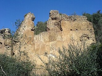
Tubusuctu also known as Colonia Iulia Augusta Legionis VII, was a Roman colony founded by Augustus for military veterans and known for its olive oil.
People
Climate
| Population | 31,890 |
| Population Density | 1,472 / sq mi |
| Elevation | 308 ft (94 m) |
| Coordinates | 36.6500°, 4.7736° |
| Timezone | Africa/Algiers |
| Country | 🇩🇿 Algeria |
| State / Province | Béjaïa |
| Average Temperature | 62°F (16°C) |
| January Average | 47°F (9°C) |
| July Average | 78°F (26°C) |
| Annual Precipitation | 28.0 inches (710 mm) |
| Annual Snowfall | 0.0 inches (0 cm) |
About el hed
el hed is a mid-size city in Algeria (Béjaïa) with a population of 31,890. The city sits at an elevation of 308 feet (94 meters) above sea level. The average annual temperature is 62°F (16°C). Temperatures range from 47°F in January to 78°F in July. Annual precipitation averages 28.0 inches. The timezone is Africa/Algiers.
Climate in el hed
el hed has an average annual temperature of 18.5°C (65°F). The hottest month is Aug (26.2°C), the coldest is Feb (12°C). Average annual precipitation is 762 mm.
Temperature
| Annual Average | 61.6°F |
| 14% above Algeria avg | |
| January Average | 47°F (9°C) |
| July Average | 78°F (26°C) |
| Sunny Days | 285 days/yr |
Geography
| Elevation | 308 ft (94 m) |
| Area | 21.7 sq mi (56.1 km²) |
| Population Density | 1,472/sq mi |
| Coordinates | 36.6500°N, 4.7736°W |
| Timezone | Africa/Algiers |
Precipitation & Snow
Air Quality
Tsunami History
5 tsunamis recorded within 500 km. Highest wave on record: 5.0 m (16 ft).
| Year | Location | Cause | Max Wave | Deaths | Distance |
| 1856 | SEA OF ALBORAN | Earthquake | 5.0 m | 8 | 96 km |
| 1856 | SEA OF ALBORAN | Earthquake | 3.8 m | 5 | 96 km |
| 2003 | N. ALGERIA | Earthquake | 3.0 m | 2,287 | 107 km |
| 2003 | ALGIERS | Earthquake | 0.1 m | 9 | 111 km |
| 2021 | N. ALGERIA | Earthquake | 0.1 m | — | 48 km |
Monthly Weather
| Month | Avg Temperature | Precipitation | Summary |
|---|---|---|---|
| January | 47°F (9°C) | 4.8 in | Coldest, Wettest |
| February | 49°F (9°C) | 3.1 in | |
| March | 52°F (11°C) | 3.4 in | |
| April | 57°F (14°C) | 2.4 in | |
| May | 64°F (18°C) | 1.7 in | |
| June | 72°F (22°C) | 0.9 in | |
| July | 78°F (26°C) | 0.2 in | Driest |
| August | 79°F (26°C) | 0.4 in | Warmest |
| September | 73°F (23°C) | 1.3 in | |
| October | 65°F (18°C) | 2.2 in | |
| November | 56°F (13°C) | 3.7 in | |
| December | 49°F (9°C) | 3.9 in |
el hed has a seasonal temperature swing of 32°F / from 47°F in January to 79°F in August. Total annual precipitation is 28.0 inches, with January being the wettest month (4.8") and July the driest (0.2").
Schools in el hed
21 public schools (NCES 2022-23 data).
| School | Level | Enrollment | Teachers | Student/Teacher |
|---|---|---|---|---|
| Primaire Abainou 01 | — | — | — | — |
| Primaire Abainou 02 | — | — | — | — |
| C.E.M Ideraken | — | — | — | — |
| Lycée Timezrit (Benhaddad) | — | — | — | — |
| Primaire Amssioune | — | — | — | — |
| CEM 800-300 | — | — | — | — |
| École primaire Si Ahmed Ahmed | — | — | — | — |
| Centre de Formation Professionel | — | — | — | — |
| Primaire Igoussimen Mohand Ouali | — | — | — | — |
| Ecole Primaire Remila Said Bekhat | — | — | — | — |
| Lycée de Timezrit | — | — | — | — |
| Aɣerbaz Alemmas Aziru Md uyidir CEM Azirou Md Ouidir | — | — | — | — |
| CEM Tasga | — | — | — | — |
| CEM Ait Amara Hocine | — | — | — | — |
| C.F.P.A Timezrit | — | — | — | — |
| Ecole primaire Akabiou | — | — | — | — |
| CEM Ilmaten | — | — | — | — |
| Ecole primaire El Had | — | — | — | — |
| Primaire Ideraken | — | — | — | — |
| Aɣerbaz Amezwaru École primaire | — | — | — | — |
| Centre de Formation Profesionnel | — | — | — | — |
Radio Stations near el hed
0 stations within ~55 km.
| Station | Genre | Quality |
|---|
Museums in el hed
| Name | Type | Address | Phone | Annual Revenue |
|---|---|---|---|---|
| EX Palais de Justice | ||||
| La mairie | ||||
| Musée de l'Eau | ||||
| Musée du Martyr |
Libraries in el hed
| Name | Address | Staff | Annual Visits | Circulation | Collection | Programs |
|---|---|---|---|---|---|---|
| Akbou Papeterie | 0.0 | |||||
| Bibliothèque Centrale | 0.0 | |||||
| Bibliothéque Communal | 0.0 | |||||
| Bibliothèque Communale de Bouhamza | 0.0 | |||||
| Bibliothèque municipale | 0.0 | |||||
| Bibliothèque municipale | 0.0 | |||||
| Bibliothèque municipale de sidi aïch | 0.0 | |||||
| Bibliothèque municipale de sidi aïch | 0.0 | |||||
| Bibliothèque municipale de Souk Oufella | 0.0 | |||||
| Bibliothèques | 0.0 | |||||
| Biobliothèque communale de Tibane | 0.0 | |||||
| Kiosque Bouda | 0.0 | |||||
| Kiosque Chic Choc | 0.0 | |||||
| Lǧameε n timsilt - Yacine Bettar | 0.0 | |||||
| Tamkarḍit n taɣiwant | 0.0 |
Farmers Markets in el hed
| Name | Address | Season | Hours | Organic | Website |
|---|---|---|---|---|---|
| Maché Hebdomadaire | |||||
| Marché aux bovins | |||||
| Marché couvert de Sidi Aïch | |||||
| Marché couvert de Sidi-Aïch | |||||
| Marché d'Amizour | |||||
| Marché du vendredi | |||||
| Marché El Had | |||||
| Marché hebdomadaire | |||||
| Seddouk market |
Restaurants in el hed
1 restaurants within city radius — OpenStreetMap data
Cafes in el hed
11 cafes within city radius — OpenStreetMap data
Clinics in el hed
5 clinics within city radius — OpenStreetMap data
Gas Stations in el hed
6 gas stations within city radius — OpenStreetMap data
Shopping Malls in el hed
4 shopping malls within city radius — OpenStreetMap data
Stadiums & Teams in el hed
| Team | League | Division |
|---|---|---|
Airports Near el hed
2 airports within the area.
| Airport | IATA | Type |
|---|---|---|
| Soummam–Abane Ramdane Airport | BJA | Large Airport |
| Ain Arnat Airport | QSF | Medium Airport |
Post Offices in el hed
7 post offices.
| Post Office | Address |
|---|---|
| Bureau Algérie Poste | |
| Bureau de poste | |
| Bureau de poste de Abainou | |
| Bureau de poste Ideraken | |
| Bureau de poste Ilmaten | |
| Bureau de poste Soummam | |
| Tizi El Qarn |
Churches & Religious Organizations in el hed
11 religious organizations (IRS tax-exempt data).
| Name | Address |
|---|---|
| Aghomras mosque | |
| Ali Chaâbi | |
| Cheurfa Mosque | |
| Lǧameɛ Ugerbi | |
| mosque essalam | |
| mosque ilmaten | |
| Mosque Soummam | |
| Mosque Takhlicht | |
| Mosque Takhlicht Wada | |
| mosque tissa | |
| Sidi Ayad |
Quick Facts
🇩🇿 About Algeria
Frequently Asked Questions About el hed
What is the population of el hed?
el hed has a population of 31,890 residents and is located in Algeria. The population density is 1,472 people per square mile, spread across 21.7 square miles.
What is the weather like in el hed?
el hed enjoys a temperate climate with an average annual temperature of 62°F (16°C). Winter temperatures average 47°F in January, while summers reach an average of 78°F in July. The area receives 285 sunny days per year, well above the national average of 205. Annual rainfall totals 28.0 inches.