Fărcaşele, Romania
Olt · Romania
Fărcaşele is a small town in Olt, Romania with a population of 1,056. Elevation: 289 ft (88 m). Average temperature: 58°F (15°C).
Population source: Wikidata (dated census and official estimates), GeoNames. Climate: WorldClim 2.1 normals (1970-2000), NASA POWER. Updated August 2026
Discover Fărcaşele, Romania
Explore over 40 sections covering people, economy, housing, health, crime, climate, community, costs, trends, schools, colleges, hospitals, treatment centers, industries, museums, libraries, breweries, farmers markets, grocery stores, pharmacies, campgrounds, parks, trails, stadiums, ski resorts, daycare centers, nursing homes, churches, fire stations, cell towers, bridges, power plants, EV stations, prisons, radio stations, airports, police stations, post offices, Amtrak stations, superfund sites, UNESCO sites, and more.
Use the tabs and dropdown menus below to navigate every data point we track for this city.
About Fărcaşele
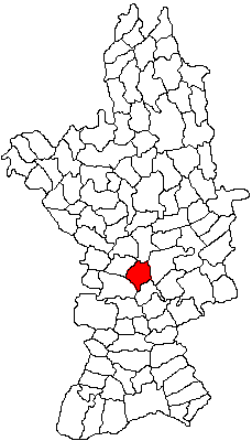
Fărcașele is a commune in Olt County, Oltenia, Romania. It is composed of four villages: Fărcașele, Fărcașu de Jos, Ghimpați and Hotărani.
People
Climate
| Population | 1,056 |
| Population Density | 45 / sq mi |
| Elevation | 289 ft (88 m) |
| Coordinates | 44.1500°, 24.4333° |
| Timezone | Europe/Bucharest |
| Country | 🇷🇴 Romania |
| State / Province | Olt |
| Average Temperature | 58°F (15°C) |
| January Average | 40°F (5°C) |
| July Average | 81°F (27°C) |
| Annual Precipitation | 22.5 inches (571 mm) |
| Annual Snowfall | 8.3 inches (21 cm) |
About Fărcaşele
Fărcaşele is a small town in Romania (Olt) with a population of 1,056. The city sits at an elevation of 289 feet (88 meters) above sea level. The average annual temperature is 58°F (15°C). Temperatures range from 40°F in January to 81°F in July. Annual precipitation averages 22.5 inches. The timezone is Europe/Bucharest.
Temperature
| Annual Average | 58.1°F |
| 8% above Romania avg | |
| January Average | 40°F (5°C) |
| July Average | 81°F (27°C) |
Geography
| Elevation | 289 ft (88 m) |
| Area | 23.6 sq mi (61.1 km²) |
| Population Density | 45/sq mi |
| Coordinates | 44.1500°N, 24.4333°E |
| Timezone | Europe/Bucharest |
Precipitation & Snow
Air Quality
Monthly Weather
| Month | Avg Temperature | Precipitation | Summary |
|---|---|---|---|
| January | 40°F (5°C) | 1.4 in | |
| February | 34°F (1°C) | 1.4 in | |
| March | 43°F (6°C) | 1.5 in | |
| April | 54°F (12°C) | 1.8 in | |
| May | 63°F (17°C) | 2.5 in | |
| June | 70°F (21°C) | 2.8 in | Wettest |
| July | 81°F (27°C) | 2.5 in | Warmest |
| August | 73°F (23°C) | 1.8 in | |
| September | 65°F (18°C) | 1.3 in | Driest |
| October | 54°F (12°C) | 1.3 in | |
| November | 41°F (5°C) | 1.8 in | |
| December | 33°F (0°C) | 1.7 in | Coldest |
Fărcaşele has a seasonal temperature swing of 48°F / from 33°F in December to 81°F in July. Total annual precipitation is 21.8 inches, with June being the wettest month (2.8") and September the driest (1.3").
Museums in Fărcaşele
| Name | Type | Address | Phone | Annual Revenue |
|---|---|---|---|---|
| "Iancu Jianu" Memorial House | ||||
| Boian Plain Museum | ||||
| Boianu Ethnographic Museum Complex | ||||
| Brancoveni Monastery Museum | ||||
| Cetatea Geto Dacică | ||||
| Colecția de Arheologie și Etnografie | ||||
| Documentary Exhibition "Military Priests of the Olt County" | ||||
| Museum | ||||
| Museum of Romanati | ||||
| Museum of Romanati. Fine Arts Department | ||||
| Punct Muzeal | ||||
| Sprancenata Village Museum Collection |
Libraries in Fărcaşele
| Name | Address | Staff | Annual Visits | Circulation | Collection | Programs |
|---|---|---|---|---|---|---|
| Biblioteca Comunală Cilieni | 0.0 | |||||
| Librăria Nicolae Titulescu | 0.0 |
Farmers Markets in Fărcaşele
| Name | Address | Season | Hours | Organic | Website |
|---|---|---|---|---|---|
| Piața | |||||
| Piața agroalimentară | |||||
| Piața Agroalimentară Caracal | |||||
| Târg săptămânal Traian | |||||
| Târgul Bucinișu |
Stadiums & Teams in Fărcaşele
| Team | League | Division |
|---|---|---|
Airports Near Fărcaşele
14 airports within the area.
| Airport | IATA | Type |
|---|---|---|
| Craiova International Airport | CRA | Large Airport |
| Dolna Mitropoliya Air Base | - | Medium Airport |
| Balta Verde Airfield | - | Small Airport |
| Borovan Airstrip | - | Small Airport |
| Brenitsa Airstrip | - | Small Airport |
| Geamăna Airfield | - | Small Airport |
| Grivitsa Airfield | - | Small Airport |
| Knezha Airstrip | - | Small Airport |
| Selanovtsi Airfield | - | Small Airport |
| Slavovitsa Airstrip | - | Small Airport |
| Sokolare Highway Strip | - | Small Airport |
| Staroseltsi | - | Small Airport |
| Topoloveni Airfield | - | Small Airport |
| Vabel Airstrip | - | Small Airport |
Churches & Religious Organizations in Fărcaşele
1 religious organizations (IRS tax-exempt data).
| Name | Address |
|---|---|
| Biserica "Sf. Ier. Nicolae" |
Quick Facts
🇷🇴 About Romania
Public Holidays in Romania
17 public holidays this year
Download Full City Report
Get a comprehensive, print-ready PDF with all data for Fărcaşele.
Get ReportFrequently Asked Questions About Fărcaşele
What is the population of Fărcaşele?
Fărcaşele has a population of 1,056 residents and is located in Romania. The population density is 45 people per square mile, spread across 23.6 square miles.
What is the weather like in Fărcaşele?
Fărcaşele enjoys a temperate climate with an average annual temperature of 58°F (15°C). Winter temperatures average 40°F in January, while summers reach an average of 81°F in July. Annual rainfall totals 22.5 inches, with 8.3 inches of snow.
Nearby Cities
Want every data point for Fărcaşele?
The full profile puts all sections on one printable page, no tabs.
Full City Profile