 All Countries


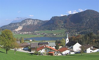
Hinterthiersee, Austria
Tyrol · Austria
Hinterthiersee is a small town in Tyrol, Austria with a population of 502. Elevation: 2,799 ft (853 m). Average temperature: 50°F (10°C).
Data updated June 2026
Discover Hinterthiersee, Austria
Explore over 40 sections covering people, economy, housing, health, crime, climate, community, costs, trends, schools, colleges, hospitals, treatment centers, industries, museums, libraries, breweries, farmers markets, grocery stores, pharmacies, campgrounds, parks, trails, stadiums, ski resorts, daycare centers, nursing homes, churches, fire stations, cell towers, bridges, power plants, EV stations, prisons, radio stations, airports, police stations, post offices, Amtrak stations, superfund sites, UNESCO sites, and more.
Use the tabs and dropdown menus below to navigate every data point we track for this city.
About Hinterthiersee
Thiersee is a large municipality in the Kufstein district in the Austrian state of Tyrol located 5 km west of Kufstein, below the northern border with Bavaria, Germany.
People
Economy
B+Climate
| Population | 502 |
| Population Density | 41 / sq mi |
| Elevation | 2,799 ft (853 m) |
| Coordinates | 47.5833°, 12.0667° |
| Timezone | Europe/Vienna |
| Country | 🇦🇹 Austria |
| State / Province | Tyrol |
| Average Temperature | 50°F (10°C) |
| January Average | 33°F (1°C) |
| July Average | 66°F (19°C) |
| Annual Precipitation | 62.8 inches (1,596 mm) |
| Annual Snowfall | 98.3 inches (250 cm) |
| Median Household Income | $71,064 |
About Hinterthiersee
Hinterthiersee is a small town in Austria (Tyrol) with a population of 502. The city sits at an elevation of 2,799 feet (853 meters) above sea level. The average annual temperature is 50°F (10°C). Temperatures range from 33°F in January to 66°F in July. Annual precipitation averages 62.8 inches. The timezone is Europe/Vienna.
Income: Hinterthiersee vs Austria
Commute Mode
Income
| Median HH Income | $71,064 |
| 5% below Austria avg |
Employment & Poverty
| Establishments (County) | 20 |
Business (County)
Tax & Cost of Living
Commute & Transportation
Walkability
Climate in Hinterthiersee
Hinterthiersee has an average annual temperature of 9.2°C (49°F). The hottest month is Jul (18.6°C), the coldest is Jan (-0.8°C). Average annual precipitation is 1393 mm.
Temperature
| Annual Average | 49.7°F |
| 8% below Austria avg | |
| January Average | 33°F (1°C) |
| July Average | 66°F (19°C) |
| Sunny Days | 242 days/yr |
Geography
| Elevation | 2,799 ft (853 m) |
| Area | 12.3 sq mi (31.9 km²) |
| Population Density | 41/sq mi |
| Coordinates | 47.5833°N, 12.0667°W |
| Timezone | Europe/Vienna |
Precipitation & Snow
Air Quality
Tsunami History
1 tsunami recorded within 500 km. Highest wave on record: 235.0 m (771 ft).
| Year | Location | Cause | Max Wave | Deaths | Distance |
| 1963 | VAJONT DAM, VAJONT RIVER | Meteorological | 235.0 m | 2,000 | 148 km |
Monthly Weather
| Month | Avg Temperature | Precipitation | Summary |
|---|---|---|---|
| January | 33°F (1°C) | 2.8 in | |
| February | 31°F (-0°C) | 2.8 in | Driest |
| March | 38°F (3°C) | 3.4 in | |
| April | 44°F (6°C) | 3.6 in | |
| May | 53°F (12°C) | 4.5 in | |
| June | 58°F (14°C) | 6.3 in | |
| July | 66°F (19°C) | 6.9 in | Warmest, Wettest |
| August | 61°F (16°C) | 6.1 in | |
| September | 55°F (13°C) | 4.1 in | |
| October | 47°F (8°C) | 3.0 in | |
| November | 37°F (3°C) | 3.6 in | |
| December | 31°F (-1°C) | 3.3 in | Coldest |
Hinterthiersee has a seasonal temperature swing of 36°F / from 31°F in December to 66°F in July. Total annual precipitation is 50.4 inches, with July being the wettest month (6.9") and February the driest (2.8").
Schools in Hinterthiersee
2 public schools (NCES 2022-23 data).
| School | Level | Enrollment | Teachers | Student/Teacher |
|---|---|---|---|---|
| Volksschule Hinterthiersee | — | — | — | — |
| Volksschule Landl | — | — | — | — |
Radio Stations near Hinterthiersee
5 stations within ~55 km.
| Station | Genre | Quality | |
|---|---|---|---|
| Radio Charivari (DE) | pop, public radio | MP3 128 kbps | |
| U1 Tirol | evergreen, schlager | MP3 192 kbps | |
| Radio Charivari Rosenheim (DE) | classic hits, hits | AAC | |
| Alpenweihnacht (DE) | alpen, volksmusik | MP3 128 kbps | |
| Munichs Hardest Hits (DE) | classic rock | MP3 |
Museums in Hinterthiersee
| Name | Type | Address | Phone | Annual Revenue |
|---|---|---|---|---|
| Augustinermuseum | ||||
| Bauernhausmuseum | ||||
| Bergbauernmuseum | ||||
| Bergbauernmuseum z'Bach | ||||
| Bergbaumuseum | ||||
| Bergdoktor-Praxis | ||||
| Brechlstube | ||||
| Dorf- und Höhlenmuseum | ||||
| Freiluft ZementMuseum | ||||
| Fuizn Museum | ||||
| Galerie Schmidt | ||||
| Heimatmuseum | ||||
| Heimatmuseum | ||||
| Heimatmuseum | ||||
| Heimatmuseum - Alte Schmiede | ||||
| Heimatmuseum Schliersee | ||||
| Holzmuseum | ||||
| Industriemuseum Blaahaus | ||||
| Inn Maritime Museum | ||||
| madersperger | ||||
| Markus Wasmeier Freilichtmuseum | ||||
| Müllner Peter Museum | ||||
| Museum im Burgtor | ||||
| Museum in den Nagelschmiedhäusern | ||||
| Museum of Local History | ||||
| Museum Tiroler Bauernhöfe | ||||
| Museum Tiroler Bauernhöfe | ||||
| Museumsfriedhof | ||||
| Pfarrmuseum | ||||
| Plättenstadl | ||||
| Stettauer Mühle | ||||
| Tiroler Bergbau- und Hüttenmuseum | ||||
| Urweltmuseum | ||||
| Whisky-Destillerie Slyrs |
Libraries in Hinterthiersee
| Name | Address | Staff | Annual Visits | Circulation | Collection | Programs |
|---|---|---|---|---|---|---|
| Bibliothek Rattenberg | 0.0 | |||||
| Bücherei | 0.0 | |||||
| Bücherei | 0.0 | |||||
| Bücherei | 0.0 | |||||
| Bücherei | 0.0 | |||||
| Bücherei | 0.0 | |||||
| Bücherei Bad Feilnbach | 0.0 | |||||
| Bücherei Thiersee | 0.0 | |||||
| City Library | 0.0 | |||||
| Gemeindebücherei | 0.0 | |||||
| Gemeindebücherei | 0.0 | |||||
| Gemeindebücherei | 0.0 | |||||
| Gemeindebücherei | 0.0 | |||||
| Gemeindebücherei Bad Häring | 0.0 | |||||
| Gemeindebücherei Höhenmoos | 0.0 | |||||
| Jukie | 0.0 | |||||
| Kath. öffentl. Bücherei Degerndorf/Brannenburg | 0.0 | |||||
| Katholische Öffentliche Bücherei Pang | 0.0 | |||||
| Kubi - Kufstein Library | 0.0 | |||||
| Öffentliche Bücherei | 0.0 | |||||
| Pfarr- und Gemeindebücherei Oberaudorf | 0.0 | |||||
| Pfarrbücherei | 0.0 | |||||
| Pfarrbücherei | 0.0 | |||||
| Stadtbücherei | 0.0 |
Farmers Markets in Hinterthiersee
| Name | Address | Season | Hours | Organic | Website |
|---|---|---|---|---|---|
| Bad Feilnbacher Wochenmarkt | |||||
| Wörgler Bauernmarkt |
Hotels in Hinterthiersee
6 hotels within city radius — OpenStreetMap data
Restaurants in Hinterthiersee
5 restaurants within city radius — OpenStreetMap data
Breweries in Hinterthiersee
| Name | Type | Address | Phone | Website |
|---|---|---|---|---|
| Bierol | ||||
| Kristallbrauerei Alpbach | ||||
| Oberaudorfer Privatbrauerei | ||||
| SH | ||||
| Silbernagel | ||||
| Weißbierbrauerei Hopf | ||||
| Wildschönau Brewery |
Stadiums & Teams in Hinterthiersee
| Team | League | Division |
|---|---|---|
Ski Resorts Near Hinterthiersee
51 ski resorts within range.
| Resort | Slopes (km) | Lifts | Peak (m) | Price | Season | Night | Park |
|---|---|---|---|---|---|---|---|
| Hausberglift - Waidring | 0.0 | — | — | $0 | — | — | — |
| Schmittenhöhe Zell am See | 0.0 | — | — | $0 | — | — | — |
| KitzSki | 0.0 | — | — | $0 | — | — | — |
| Ski Juwel Alpbachtal Wildschönau | 0.0 | — | — | $0 | — | — | — |
| Ski Juwel - Reith im Alpbachtal | 0.0 | — | — | $0 | — | — | — |
| Skicircus Saalbach-Hinterglemm Leogang Fieberbrunn | 0.0 | — | — | $0 | — | — | — |
| Karwendel Bergbahn | 0.0 | — | — | $0 | — | — | — |
| Rofan Seilbahn | 0.0 | — | — | $0 | — | — | — |
| Niederau (Wildschönau) | 0.0 | — | — | $0 | — | — | — |
| SkiWelt Wilder Kaiser Brixental | 0.0 | — | — | $0 | — | — | — |
| Buchensteinwand (Pillersee) | 0.0 | — | — | $0 | — | — | — |
| St. Johann in Tirol | 0.0 | — | — | $0 | — | — | — |
| Christlum | 0.0 | — | — | $0 | — | — | — |
| Kellerjoch | 0.0 | — | — | $0 | — | — | — |
| Almenwelt Lofer | 0.0 | — | — | $0 | — | — | — |
| Steinplatte Waidring-Tirol | 0.0 | — | — | $0 | — | — | — |
| Zahmer Kaiser | 0.0 | — | — | $0 | — | — | — |
| Hochkössen - Unterberghorn | 0.0 | — | — | $0 | — | — | — |
| Spitzingsee-Tegernsee | 0.0 | — | — | $0 | — | — | — |
| Wildalmlifte | 0.0 | — | — | $0 | — | — | — |
| Brauneck | 0.0 | — | — | $0 | — | — | — |
| Sudelfeld - Bayrischzell | 0.0 | — | — | $0 | — | — | — |
| Grafenherberge (Rankenlift) | 0.0 | — | — | $0 | — | — | — |
| Hochfelln | 0.0 | — | — | $0 | — | — | — |
| Skilift Beuerberg | 0.0 | — | — | $0 | — | — | — |
| Herrnberg | 0.0 | — | — | $0 | — | — | — |
| Kitzsteinhorn | 0.0 | — | — | $0 | — | — | — |
| Rosskopf | 0.0 | — | — | $0 | — | — | — |
| Speikboden | 0.0 | — | — | $0 | — | — | — |
| Rein in Taufers - Riva di Tures | 0.0 | — | — | $0 | — | — | — |
| Klausberg Skiarena | 0.0 | — | — | $0 | — | — | — |
| Klausberg - Monte Chiusetta | 0.0 | — | — | $0 | — | — | — |
| Kals-Matrei | 0.0 | — | — | $0 | — | — | — |
| Bergeralm | 0.0 | — | — | $0 | — | — | — |
| Hintertuxer Gletscher | 0.0 | — | — | $0 | — | — | — |
| Skilift Floiten Ginzling | 0.0 | — | — | $0 | — | — | — |
| Weißsee Gletscherwelt | 0.0 | — | — | $0 | — | — | — |
| Serlesbahnen | 0.0 | — | — | $0 | — | — | — |
| Mayrhofen Hippach | 0.0 | — | — | $0 | — | — | — |
| Brunnalm / St. Jakob | 0.0 | — | — | $0 | — | — | — |
| Gerlosstein / Hainzenberg | 0.0 | — | — | $0 | — | — | — |
| Patscherkofel | 0.0 | — | — | $0 | — | — | — |
| Wintersportschule Krimml | 0.0 | — | — | $0 | — | — | — |
| Glungezer | 0.0 | — | — | $0 | — | — | — |
| Zillertal Arena | 0.0 | — | — | $0 | — | — | — |
| Bergisel Schanze | 0.0 | — | — | $0 | — | — | — |
| Maiskogel | 0.0 | — | — | $0 | — | — | — |
| Skigebiet Hochfügen - Zillertal | 0.0 | — | — | $0 | — | — | — |
| Wildkogel | 0.0 | — | — | $0 | — | — | — |
| Nordkette | 0.0 | — | — | $0 | — | — | — |
| Spieljoch - Fügen | 0.0 | — | — | $0 | — | — | — |
Airports Near Hinterthiersee
30 airports within the area.
| Airport | IATA | Type |
|---|---|---|
| Innsbruck Airport | INN | Large Airport |
| Altötting Airfield | — | Small Airport |
| Ampfing-Waldkraiburg Airfield | — | Small Airport |
| Antersberg Airfield | — | Small Airport |
| Bad Endorf/Jolling Airfield | — | Small Airport |
| Benediktbeuern Airfield | — | Small Airport |
| Brannenburg Airfield | — | Small Airport |
| Campo Volo Trens | — | Small Airport |
| Dachau-Gröbenried Airfield | — | Small Airport |
| Felling Airfield | — | Small Airport |
| Geitau Airfield | — | Small Airport |
| Grabenstätt Airfield | — | Small Airport |
| Greiling Airfield | — | Small Airport |
| Heimatshofen Private Airstrip UL | — | Small Airport |
| Kleinhartpenning UL | — | Small Airport |
| Königsdorf Gliding Center | — | Small Airport |
| Kufstein-Langkampfen Airfield | — | Small Airport |
| Mühldorf Airfield | — | Small Airport |
| Sankt Johann Airfield | — | Small Airport |
| Schleissheim Airfield | — | Small Airport |
| Schönberg Airfield | — | Small Airport |
| Sollach Airstrip | — | Small Airport |
| Sterzing / Vipiteno Airfield | — | Small Airport |
| Straßham Ultralight Airfield | — | Small Airport |
| Unterwössen Airfield | — | Small Airport |
| Vogtareuth Airfield | — | Small Airport |
| Wangen bei Starnberg Airfield | — | Small Airport |
| Warngau Airfield | — | Small Airport |
| Wasentegernbach | — | Small Airport |
| Zell am See Airfield | — | Small Airport |
Treatment Centers in Hinterthiersee
6 treatment centers.
| Center | Type | Phone |
|---|---|---|
| Ambulantes Rehazentrum VITREA | ||
| Armona Medical Alpinresort | ||
| Blumenhof Klinik | ||
| Haus Schwarzenberg | ||
| Reha Zentrum Münster | ||
| Rehabilitationszentrum Bad Häring |
Churches & Religious Organizations in Hinterthiersee
7 religious organizations (IRS tax-exempt data).
| Name | Address |
|---|---|
| Ascherkapelle | |
| Haltkapelle | |
| Mariahilf Kapelle | |
| Pfarrkirche Maria Hilf | |
| Pfarrkirche Sankt Nikolaus | |
| Rohrmooskapelle | |
| Wörthkapelle |
Explore Near Hinterthiersee
Quick Facts
🇦🇹 About Austria
Public Holidays in Austria
20 public holidays this year
Download Full City Report
Get a comprehensive, print-ready PDF with all data for Hinterthiersee.
Get ReportFrequently Asked Questions About Hinterthiersee
What is the population of Hinterthiersee?
Hinterthiersee has a population of 502 residents and is located in Austria. The population density is 41 people per square mile, spread across 12.3 square miles.
Is Hinterthiersee expensive to live in?
The median household income is $71,064, 5% below the national average of $75,149.
What is the weather like in Hinterthiersee?
Hinterthiersee has a four-season climate with an average annual temperature of 50°F (10°C). Winter temperatures average 33°F in January, while summers reach an average of 66°F in July. The area receives 242 sunny days per year. Annual rainfall totals 62.8 inches, with 98.3 inches of snow.
How is the job market in Hinterthiersee?
There are 20 business establishments in the area.