 All Countries


Namioka, Japan
Aomori · Japan
Namioka is a small city in Aomori, Japan with a population of 20,681. Elevation: 92 ft (28 m). Average temperature: 49°F (10°C).
Discover Namioka, Japan
Explore over 40 sections covering people, economy, housing, health, crime, climate, community, costs, trends, schools, colleges, hospitals, treatment centers, industries, museums, libraries, breweries, farmers markets, grocery stores, pharmacies, campgrounds, parks, trails, stadiums, ski resorts, daycare centers, nursing homes, churches, fire stations, cell towers, bridges, power plants, EV stations, prisons, radio stations, airports, police stations, post offices, Amtrak stations, superfund sites, UNESCO sites, and more.
Use the tabs and dropdown menus below to navigate every data point we track for this city.
About Namioka
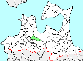
Namioka was a town located in Minamitsugaru District in central Aomori Prefecture, Japan.
People
Economy
BHousing
A+Climate
| Population | 20,681 |
| Population Density | 405 / sq mi |
| Elevation | 92 ft (28 m) |
| Coordinates | 40.7107°, 140.5905° |
| Timezone | Asia/Tokyo |
| Country | 🇯🇵 Japan |
| State / Province | Aomori |
| Average Temperature | 49°F (10°C) |
| January Average | 28°F (-2°C) |
| July Average | 70°F (21°C) |
| Annual Precipitation | 51.5 inches (1,307 mm) |
| Annual Snowfall | 16.5 inches (42 cm) |
| Median Household Income | $25,400 |
| Median Age | 51.4 years |
About Namioka
Namioka is a small city in Japan (Aomori) with a population of 20,681. The city sits at an elevation of 92 feet (28 meters) above sea level. The average annual temperature is 49°F (10°C). Temperatures range from 28°F in January to 70°F in July. Annual precipitation averages 51.5 inches. The timezone is Asia/Tokyo.
Population
Language Spoken at Home
Social Characteristics
Namioka vs Japan Average
Income: Namioka vs Japan
Commute Mode
Income
| Median HH Income | $25,400 |
| 66% below Japan avg |
Employment & Poverty
| Unemployment | 3.1% |
| 14% below Japan avg | |
| Establishments (County) | 662 |
Business (County)
Tax & Cost of Living
Commute & Transportation
Walkability
Home Value Sources
Ownership Split
Home Values
| Census Median | $62,000 |
| 78% below Japan avg |
Real Estate Market (Redfin)
Rental Costs
| Census Median Rent | $310 |
| 73% below Japan avg |
Ownership & Property
| Housing Units | 8,272 |
Property Tax
Climate in Namioka
Namioka has an average annual temperature of 11°C (52°F). The hottest month is Aug (24°C), the coldest is Jan (-0.8°C). Average annual precipitation is 1358 mm.
Temperature
| Annual Average | 49.4°F |
| 9% below Japan avg | |
| January Average | 28°F (-2°C) |
| July Average | 70°F (21°C) |
| Sunny Days | 243 days/yr |
Geography
| Elevation | 92 ft (28 m) |
| Area | 51.0 sq mi (132.1 km²) |
| Population Density | 405/sq mi |
| Coordinates | 40.7107°N, 140.5905°W |
| Timezone | Asia/Tokyo |
Precipitation & Snow
Air Quality
Tsunami History
18 tsunamis recorded within 500 km. Highest wave on record: 90.0 m (295 ft).
| Year | Location | Cause | Max Wave | Deaths | Distance |
| 1741 | W. HOKKAIDO ISLAND | Explosion | 90.0 m | 2,000 | 135 km |
| 1983 | NOSHIRO, JAPAN | Earthquake | 14.9 m | 104 | 129 km |
| 1763 | SANRIKU | Earthquake | 5.0 m | — | 119 km |
| 1793 | W. OFF AOMORI | Earthquake | 1.8 m | 12 | 56 km |
| 1939 | NW. HONSHU ISLAND | Earthquake | 1.2 m | 27 | 115 km |
| 1983 | N. HONSHU ISLAND | Earthquake | 1.0 m | — | 144 km |
| 1810 | NW. HONSHU ISLAND | Earthquake | 1.0 m | 57 | 108 km |
| 2025 | OFF NORTHEAST COAST HONSHU | Earthquake | 0.7 m | — | 137 km |
| 1983 | NOSHIRO, JAPAN | Earthquake | 0.6 m | — | 148 km |
| 1964 | NW. HONSHU ISLAND | Earthquake | 0.6 m | — | 142 km |
| 1912 | SANRIKU | Earthquake | 0.5 m | — | 121 km |
| 1945 | SANRIKU | Earthquake | 0.4 m | 2 | 129 km |
| 1901 | OFF NORTHEAST COAST HONSHU | Earthquake | 0.3 m | 18 | 145 km |
| 1964 | NW. HONSHU ISLAND | Earthquake | 0.1 m | — | 147 km |
| 1964 | NW. HONSHU ISLAND | Earthquake | — | — | 139 km |
| 1766 | SANRIKU | Earthquake | — | 1,700 | 23 km |
| 1763 | SANRIKU, HACHIONHE | Earthquake | — | — | 119 km |
| 1341 | JUSANKO, TSUGARU AOMORI PREFECTURE | Earthquake | — | 2,600 | 97 km |
Nearby Volcanoes
14 volcanoes within 200 km. Closest: Hakkodasan (25 km).
| Name | Type | Elevation | Last Eruption | Distance |
| Hakkodasan | Stratovolcano(es) | 1,585 m (5,200 ft) | 1550 | 25 km |
| Iwakisan | Stratovolcano | 1,625 m (5,331 ft) | 1863 | 25 km |
| Towada | Caldera | 1,011 m (3,317 ft) | 915 | 33 km |
| Osorezan | Stratovolcano | 878 m (2,881 ft) | 1787 | 77 km |
| Akita-Yakeyama | Stratovolcano | 1,366 m (4,482 ft) | 1997 | 84 km |
| Hachimantai | Stratovolcano | 1,613 m (5,292 ft) | -5350 | 87 km |
| Iwatesan | Complex | 2,038 m (6,686 ft) | 1919 | 102 km |
| Akita-Komagatake | Stratovolcano(es) | 1,637 m (5,371 ft) | 1971 | 107 km |
| Megata | Maar(s) | 291 m (955 ft) | -2050 | 112 km |
| Esan | Lava dome(s) | 618 m (2,028 ft) | 1874 | 131 km |
| Oshima-Oshima | Stratovolcano | 732 m (2,402 ft) | 1790 | 136 km |
| Hokkaido-Komagatake | Stratovolcano | 1,131 m (3,711 ft) | 2000 | 151 km |
| Chokaisan | Stratovolcano(es) | 2,236 m (7,336 ft) | 1974 | 185 km |
| Kurikomayama | Stratovolcano | 1,627 m (5,338 ft) | 1950 | 195 km |
Monthly Weather
| Month | Avg Temperature | Precipitation | Summary |
|---|---|---|---|
| January | 28°F (-2°C) | 4.6 in | Coldest |
| February | 29°F (-2°C) | 3.8 in | |
| March | 35°F (1°C) | 3.2 in | |
| April | 46°F (8°C) | 3.0 in | Driest |
| May | 55°F (13°C) | 3.1 in | |
| June | 62°F (17°C) | 3.5 in | |
| July | 70°F (21°C) | 4.6 in | |
| August | 73°F (23°C) | 5.6 in | Warmest |
| September | 66°F (19°C) | 5.9 in | Wettest |
| October | 54°F (12°C) | 4.7 in | |
| November | 43°F (6°C) | 4.8 in | |
| December | 33°F (0°C) | 4.9 in |
Namioka has a seasonal temperature swing of 46°F / from 28°F in January to 73°F in August. Total annual precipitation is 51.5 inches, with September being the wettest month (5.9") and April the driest (3.0").
Schools in Namioka
10 public schools (NCES 2022-23 data).
| School | Level | Enrollment | Teachers | Student/Teacher |
|---|---|---|---|---|
| 青森市立大栄小学校 | — | — | — | — |
| 青森市立浪岡中学校 | — | — | — | — |
| 青森市立浪岡南小学校 | — | — | — | — |
| 青森県立浪岡高等学校 | — | — | — | — |
| 青森市立浪岡北小学校 | — | — | — | — |
| 青森市立浪岡野沢小学校 | — | — | — | — |
| 青森市立女鹿沢小学校 | — | — | — | — |
| 青森市立本郷小学校 | — | — | — | — |
| 青森県立浪岡養護学校 | — | — | — | — |
| 五所川原市立五所川原第二中学校 | — | — | — | — |
Radio Stations near Namioka
0 stations within ~55 km.
| Station | Genre | Quality |
|---|
Museums in Namioka
| Name | Type | Address | Phone | Annual Revenue |
|---|---|---|---|---|
| Aomori Museum Of History | ||||
| Aomori City Forestry Museum | ||||
| Aomori Prefectural Museum | ||||
| Dam museum | ||||
| Hakkoda Mountain Snow Marching Victims Museum | ||||
| Hirosaki City Museum | ||||
| Jomon Jiyukan | ||||
| Memorial Ship Hakkoda-maru | ||||
| Nebuta Museum Wa Rasse | ||||
| Neputa Mura Museum | ||||
| Osamu Dazai Memorial Museum (Shayokan) | ||||
| Sanmaru Museum | ||||
| Tsugaru Shamisen Hall | ||||
| お山のおもしえ学校 | ||||
| こどもの森ビジターセンター | ||||
| つがる市縄文展示資料館 カルコ | ||||
| 五所川原市 歴史民俗資料館 | ||||
| 吉幾三コレクションミュージアム | ||||
| 太宰治「思ひ出」の館 | ||||
| 弘前藩歴史館 | ||||
| 板柳町立郷土資料館 | ||||
| 森林科学館 ジュピター | ||||
| 津軽こけし館 | ||||
| 田舎館村博物館 | ||||
| 百石町展示館 | ||||
| 立佞武多の館 | ||||
| 鏡ヶ丘記念館 | ||||
| 青森市美術館 | ||||
| 青森県立郷土館 (Aomori Prefectural Museum) |
Libraries in Namioka
| Name | Address | Staff | Annual Visits | Circulation | Collection | Programs |
|---|---|---|---|---|---|---|
| Aomori City Library | 0.0 | |||||
| Aomori City Library | 0.0 | |||||
| つがる市立図書館 | 0.0 | |||||
| 五所川原市立図書館 | 0.0 | |||||
| 弘前大学附属図書館 | 0.0 | |||||
| 弘前市立図書館 | 0.0 | |||||
| 弘前市立岩木図書館 | 0.0 | |||||
| 青森県立図書館 近代文学館 | 0.0 |
Farmers Markets in Namioka
| Name | Address | Season | Hours | Organic | Website |
|---|---|---|---|---|---|
| Food Marche | |||||
| 新鮮市場 | |||||
| 津軽りんご市場 | |||||
| 虹のマート | |||||
| 青森魚菜センター | |||||
| 青森魚菜センター |
Restaurants in Namioka
4 restaurants within city radius — OpenStreetMap data
Castles in Namioka
1 castles within city radius — OpenStreetMap data
Train Stations in Namioka
2 train stations within city radius — OpenStreetMap data
Gas Stations in Namioka
1 gas stations within city radius — OpenStreetMap data
Stadiums & Teams in Namioka
| Team | League | Division |
|---|---|---|
Ski Resorts Near Namioka
15 ski resorts within range.
| Resort | Slopes (km) | Lifts | Peak (m) | Price | Season | Night | Park |
|---|---|---|---|---|---|---|---|
| Ani Yuguchinai Ski Area | 0.0 | — | — | $0 | — | — | — |
| Okunakayamakogen Ski Area | 0.0 | — | — | $0 | — | — | — |
| Tayama Ski Area (Hachimantai City) | 0.0 | — | — | $0 | — | — | — |
| Hanawa Ski Area | 0.0 | — | — | $0 | — | — | — |
| Yakushiyama Ski Area | 0.0 | — | — | $0 | — | — | — |
| Fujisato Choei Ski Area | 0.0 | — | — | $0 | — | — | — |
| Soyumura 229 Ski Land | 0.0 | — | — | $0 | — | — | — |
| Owani Onsen Ski Resort International Area | 0.0 | — | — | $0 | — | — | — |
| Iwakisan Hyakuzawa Ski Resort | 0.0 | — | — | $0 | — | — | — |
| Hakkoda Kokusai Ski Area | 0.0 | — | — | $0 | — | — | — |
| Aomori Spring Resort | 0.0 | — | — | $0 | — | — | — |
| Moya Hills | 0.0 | — | — | $0 | — | — | — |
| Makado Onsen | 0.0 | — | — | $0 | — | — | — |
| Kase Ski Area | 0.0 | — | — | $0 | — | — | — |
| 夜越山スキー場 | 0.0 | — | — | $0 | — | — | — |
Airports Near Namioka
6 airports within the area.
| Airport | IATA | Type |
|---|---|---|
| Aomori Airport | AOJ | Large Airport |
| Odate Noshiro Airport | ONJ | Medium Airport |
| Arakawa Airstrip | — | Small Airport |
| Hirosaki Fifteen Club Airstrip | — | Small Airport |
| JMSDF Ōminato Base | — | Small Airport |
| Tashiro Nanohana Airfield | — | Small Airport |
Post Offices in Namioka
5 post offices.
| Post Office | Address |
|---|---|
| Daishaka Post Office | |
| Koya Post Office | |
| Namioka Hongo Post Office | |
| Namioka Post Office | |
| Tarusawa Post Office |
Treatment Centers in Namioka
80 treatment centers.
| Center | Type | Phone |
|---|---|---|
| Aomori Clinic | ||
| Fujita Otolaryngology Clinic | ||
| Machida Internal Medicine Clinic | ||
| Nakamichi Clinic | ||
| あおもり腎透析泌尿器科クリニック | ||
| あさり小児科クリニック | ||
| アラヤ医院 | ||
| えびな脳神経クリニック | ||
| エフ.クリニック | ||
| おきだてハートクリニック | ||
| おだぎりメンタルクリニック | ||
| かきざき胃腸科内科クリニック | ||
| くぼぞのクリニック | ||
| クリニック こころの森 | ||
| ささき耳鼻咽喉科クリニック | ||
| しんまちクリニック | ||
| しんまちクリニック | ||
| しんまち眼科 | ||
| たく内科クリニック | ||
| とよあきクリニック | ||
| ひでかず胃腸科内科 | ||
| ホワイト急便 | ||
| まつむら小児科 | ||
| まつもと内科外科クリニック | ||
| みずたに眼科 | ||
| みどり心療内科クリニック | ||
| よこの循環器呼吸器内科医院 | ||
| りょう内科 | ||
| 三上皮膚科医院 | ||
| 三戸内科胃腸科 | ||
| 三戸眼科 | ||
| 中央デイサービス リハビリクラブ | ||
| 井上整形外科 | ||
| 井上耳鼻咽喉科医院 | ||
| 今田内科 | ||
| 伊藤眼科クリニック | ||
| 加藤内科循環器科 | ||
| 安方クリニック | ||
| 岩男外科皮膚科医院 | ||
| 岸谷整形外科 | ||
| 嶋中内科循環器科 | ||
| 川口内科 | ||
| 工藤こども医院 | ||
| 工藤内科 | ||
| 工藤内科クリニック | ||
| 工藤内科クリニック | ||
| 成田あつしクリニック | ||
| 斉藤内科小児科 | ||
| 斉藤内科小児科 | ||
| 木村文祥内科 | ||
| 木村隆内科呼吸器科医院 | ||
| 村上整形外科 | ||
| 村上新町病院 | ||
| 村上病院 | ||
| 村岡整形外科クリニック | ||
| 村林内科 | ||
| 桂木クリニック | ||
| 桜庭内科 | ||
| 梅原内科胃腸科 | ||
| 浜田みやかわ眼科 | ||
| 渋谷内科 | ||
| 疾病予防施設 慈恵クリニック | ||
| 白石医院 | ||
| 石田クリニック | ||
| 神外科胃腸科医院 | ||
| 福士泌尿器科医院 | ||
| 福士胃腸科循環器科医院 | ||
| 菊池内科クリニック | ||
| 藤巻内科小児科 | ||
| 藤本クリニック | ||
| 西部整形外科医院 | ||
| 象こどもクリニック | ||
| 長島皮膚科クリーニング | ||
| 長島皮膚科クリニック | ||
| 阿部レディースクリニック | ||
| 青森保健生活協同組合 協立クリニック | ||
| 青森整形外科クリニック | ||
| 青葉こころのクリニック | ||
| 髙屋医院 | ||
| 黒滝整形外科 |
Churches & Religious Organizations in Namioka
4 religious organizations (IRS tax-exempt data).
| Name | Address |
|---|---|
| Shrine | |
| 保食神社 | |
| 十和田神社 | |
| 大石神社 |
Quick Facts
🇯🇵 About Japan
Public Holidays in Japan
16 public holidays this year
Download Full City Report
Get a comprehensive, print-ready PDF with all data for Namioka.
Get ReportFrequently Asked Questions About Namioka
What is the population of Namioka?
Namioka has a population of 20,681 residents and is located in Japan. The population density is 405 people per square mile, spread across 51.0 square miles. The median age of residents is 51.4 years, which is older than the national median of 38.9 years.
Is Namioka expensive to live in?
The median household income is $25,400, 66% below the national average of $75,149. The median home value is $62,000 (78% below the U.S. median). Renters pay a median of $310 per month, below the national average of $1,163. The home price-to-income ratio is 2.4x, indicating housing is reasonably affordable relative to local income levels.
What is the weather like in Namioka?
Namioka has a four-season climate with an average annual temperature of 49°F (10°C). Winter temperatures average 28°F in January, while summers reach an average of 70°F in July. The area receives 243 sunny days per year. Annual rainfall totals 51.5 inches, with 16.5 inches of snow.
How is the job market in Namioka?
Namioka has a healthy job market with an unemployment rate of 3.1%, near the national average of 3.6%. There are 662 business establishments in the area.
How much does housing cost in Namioka?
The median home value in Namioka is $62,000. For renters, the median monthly rent is $310.