 All Countries


Pang, Philippines
Autonomous Region in Muslim Mindanao · Philippines
Pang is a small town in Autonomous Region in Muslim Mindanao, Philippines with a population of 2,563. Elevation: 279 ft (85 m). Average temperature: 80°F (27°C).
Discover Pang, Philippines
Explore over 40 sections covering people, economy, housing, health, crime, climate, community, costs, trends, schools, colleges, hospitals, treatment centers, industries, museums, libraries, breweries, farmers markets, grocery stores, pharmacies, campgrounds, parks, trails, stadiums, ski resorts, daycare centers, nursing homes, churches, fire stations, cell towers, bridges, power plants, EV stations, prisons, radio stations, airports, police stations, post offices, Amtrak stations, superfund sites, UNESCO sites, and more.
Use the tabs and dropdown menus below to navigate every data point we track for this city.
About Pang
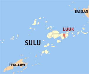
Luuk, officially the Municipality of Luuk, is a municipality in the province of Sulu, Philippines. According to the 2024 census, it has a population of 44,741 people.
People
Climate
| Population | 2,563 |
| Population Density | 86 / sq mi |
| Elevation | 279 ft (85 m) |
| Coordinates | 5.9484°, 121.2883° |
| Timezone | Asia/Manila |
| Country | 🇵🇭 Philippines |
| State / Province | Autonomous Region in Muslim Mindanao |
| Average Temperature | 80°F (27°C) |
| January Average | 79°F (26°C) |
| July Average | 81°F (27°C) |
| Annual Precipitation | 74.3 inches (1,888 mm) |
| Annual Snowfall | 0.0 inches (0 cm) |
About Pang
Pang is a small town in Philippines (Autonomous Region in Muslim Mindanao) with a population of 2,563. The city sits at an elevation of 279 feet (85 meters) above sea level. The average annual temperature is 80°F (27°C). Temperatures range from 79°F in January to 81°F in July. Annual precipitation averages 74.3 inches. The timezone is Asia/Manila.
Temperature
| Annual Average | 80.2°F |
| 49% above Philippines avg | |
| January Average | 79°F (26°C) |
| July Average | 81°F (27°C) |
| Sunny Days | 201 days/yr |
Geography
| Elevation | 279 ft (85 m) |
| Area | 29.9 sq mi (77.5 km²) |
| Population Density | 86/sq mi |
| Coordinates | 5.9484°N, 121.2883°W |
| Timezone | Asia/Manila |
Precipitation & Snow
Air Quality
Tsunami History
1 tsunami recorded within 500 km. Highest wave on record: 7.0 m (23 ft).
| Year | Location | Cause | Max Wave | Deaths | Distance |
| 1897 | SULU SEA | Earthquake | 7.0 m | 13 | 79 km |
Monthly Weather
| Month | Avg Temperature | Precipitation | Summary |
|---|---|---|---|
| January | 79°F (26°C) | 4.5 in | Coldest |
| February | 79°F (26°C) | 3.7 in | |
| March | 80°F (27°C) | 3.6 in | Driest |
| April | 80°F (27°C) | 5.2 in | |
| May | 81°F (27°C) | 8.3 in | Warmest |
| June | 81°F (27°C) | 8.9 in | Wettest |
| July | 81°F (27°C) | 6.6 in | |
| August | 81°F (27°C) | 6.3 in | |
| September | 80°F (27°C) | 7.0 in | |
| October | 80°F (27°C) | 8.8 in | |
| November | 80°F (27°C) | 6.7 in | |
| December | 80°F (27°C) | 4.8 in |
Pang has a seasonal temperature swing of 2°F / from 79°F in January to 81°F in May. Total annual precipitation is 74.3 inches, with June being the wettest month (8.9") and March the driest (3.6").
Schools in Pang
5 public schools (NCES 2022-23 data).
| School | Level | Enrollment | Teachers | Student/Teacher |
|---|---|---|---|---|
| Kanpagayoh Primary School Annex | — | — | — | — |
| Pang Elementary school | — | — | — | — |
| Masjid Bayli Proper Elementary School | — | — | — | — |
| Masjid Punjungan Elementary School – Annex I-B | — | — | — | — |
| Lambago Elementary School | — | — | — | — |
Airports Near Pang
4 airports within the area.
| Airport | IATA | Type |
|---|---|---|
| Jolo Airport | JOL | Medium Airport |
| Luuk Airport | — | Small Airport |
| Siasi Airport | — | Small Airport |
| Tumahubong Airstrip | — | Small Airport |
Quick Facts
🇵🇭 About Philippines
Public Holidays in Philippines
18 public holidays this year
Frequently Asked Questions About Pang
What is the population of Pang?
Pang has a population of 2,563 residents and is located in Philippines. The population density is 86 people per square mile, spread across 29.9 square miles.
What is the weather like in Pang?
Pang has a warm climate with an average annual temperature of 80°F (27°C). Winter temperatures average 79°F in January, while summers reach an average of 81°F in July. The area receives 201 sunny days per year. Annual rainfall totals 74.3 inches.