 All Countries


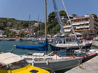
Patitírion, Greece
Thessaly · Greece
Patitírion is a small town in Thessaly, Greece with a population of 1,628. Elevation: 128 ft (39 m). Average temperature: 63°F (17°C).
Discover Patitírion, Greece
Explore over 40 sections covering people, economy, housing, health, crime, climate, community, costs, trends, schools, colleges, hospitals, treatment centers, industries, museums, libraries, breweries, farmers markets, grocery stores, pharmacies, campgrounds, parks, trails, stadiums, ski resorts, daycare centers, nursing homes, churches, fire stations, cell towers, bridges, power plants, EV stations, prisons, radio stations, airports, police stations, post offices, Amtrak stations, superfund sites, UNESCO sites, and more.
Use the tabs and dropdown menus below to navigate every data point we track for this city.
About Patitírion
Patitiri is the capital town of the island of Alonnisos in the Sporades archipelago, Greece. It is located in the southern part of the island. Patitiri was destroyed in the 1965 earthquake.
People
Economy
C+Climate
| Population | 1,628 |
| Population Density | 47 / sq mi |
| Elevation | 128 ft (39 m) |
| Coordinates | 39.1466°, 23.8649° |
| Timezone | Europe/Athens |
| Country | 🇬🇷 Greece |
| State / Province | Thessaly |
| Average Temperature | 63°F (17°C) |
| January Average | 49°F (9°C) |
| July Average | 78°F (26°C) |
| Annual Precipitation | 17.5 inches (445 mm) |
| Annual Snowfall | 0.0 inches (0 cm) |
| Median Household Income | $18,684 |
About Patitírion
Patitírion is a small town in Greece (Thessaly) with a population of 1,628. The city sits at an elevation of 128 feet (39 meters) above sea level. The average annual temperature is 63°F (17°C). Temperatures range from 49°F in January to 78°F in July. Annual precipitation averages 17.5 inches. The timezone is Europe/Athens.
Income: Patitírion vs Greece
Commute Mode
Income
| Median HH Income | $18,684 |
| 75% below Greece avg |
Employment & Poverty
| Establishments (County) | 94 |
Business (County)
Tax & Cost of Living
Commute & Transportation
Walkability
Temperature
| Annual Average | 62.5°F |
| 16% above Greece avg | |
| January Average | 49°F (9°C) |
| July Average | 78°F (26°C) |
| Sunny Days | 304 days/yr |
Geography
| Elevation | 128 ft (39 m) |
| Area | 34.6 sq mi (89.7 km²) |
| Population Density | 47/sq mi |
| Coordinates | 39.1466°N, 23.8649°W |
| Timezone | Europe/Athens |
Precipitation & Snow
Air Quality
Tsunami History
13 tsunamis recorded within 500 km. Highest wave on record: 3.0 m (10 ft).
| Year | Location | Cause | Max Wave | Deaths | Distance |
| 1965 | NORTH CORINTH GULF | Eruption + Earthquake | 3.0 m | 2 | 142 km |
| 1905 | NORTH AEGEAN SEA | Eruption + Earthquake | 3.0 m | 11 | 124 km |
| 1894 | NORTH EVOIKOS GULF | Eruption + Earthquake | 3.0 m | — | 83 km |
| 1981 | GULF OF CORINTH | Earthquake | 1.3 m | — | 116 km |
| 1968 | LEMNOS ISLAND, NORTH AEGEAN SEA | Earthquake | 1.2 m | 22 | 97 km |
| 1981 | ATHENS-EASTERN GULF OF CORINTH | Earthquake | 1.0 m | 22 | 131 km |
| 1928 | CORINTHOS-PATRAS GULF | Earthquake | 0.6 m | 20 | 148 km |
| 1992 | CORINTH GULF | Earthquake | — | — | 140 km |
| 1965 | AEGEAN SEA | Earthquake | — | 38 | 31 km |
| 1955 | VOLOS GULF | Earthquake | — | 8 | 72 km |
| 1853 | CENTRAL GREECE (EVOIKOS GULF) | Earthquake | — | 17 | 105 km |
| 1585 | NORTH AEGEAN SEA | Earthquake | — | — | 129 km |
| -426 | CORINTHOS-PATRAS GULF | Earthquake | — | 2,500 | 104 km |
Nearby Volcanoes
1 volcano within 200 km. Closest: Methana (176 km).
| Name | Type | Elevation | Last Eruption | Distance |
| Methana | Lava dome(s) | 760 m (2,493 ft) | -258 | 176 km |
Monthly Weather
| Month | Avg Temperature | Precipitation | Summary |
|---|---|---|---|
| January | 49°F (9°C) | 2.4 in | Coldest |
| February | 49°F (9°C) | 2.1 in | |
| March | 52°F (11°C) | 1.9 in | |
| April | 58°F (14°C) | 1.2 in | |
| May | 66°F (19°C) | 0.9 in | |
| June | 75°F (24°C) | 0.6 in | |
| July | 78°F (26°C) | 0.4 in | Warmest, Driest |
| August | 78°F (26°C) | 0.4 in | |
| September | 72°F (22°C) | 0.7 in | |
| October | 65°F (18°C) | 1.9 in | |
| November | 57°F (14°C) | 2.3 in | |
| December | 52°F (11°C) | 2.8 in | Wettest |
Patitírion has a seasonal temperature swing of 29°F / from 49°F in January to 78°F in July. Total annual precipitation is 17.5 inches, with December being the wettest month (2.8") and July the driest (0.4").
Radio Stations near Patitírion
3 stations within ~55 km.
| Station | Genre | Quality | |
|---|---|---|---|
| Live 89.6 | greek, mainstream | MP3 128 kbps | |
| Avanti 98.3 | greek pop, pop | MP3 128 kbps | |
| Stylida 94.1 | — | MP3 128 kbps |
Museums in Patitírion
| Name | Type | Address | Phone | Annual Revenue |
|---|---|---|---|---|
| Pirate Museum | ||||
| Traditional House | ||||
| Οικία Βακράτσα |
Hotels in Patitírion
15 hotels within city radius — OpenStreetMap data
Cafes in Patitírion
14 cafes within city radius — OpenStreetMap data
Clinics in Patitírion
1 clinics within city radius — OpenStreetMap data
Veterinaries in Patitírion
1 veterinaries within city radius — OpenStreetMap data
Bus Stations in Patitírion
2 bus stations within city radius — OpenStreetMap data
Gas Stations in Patitírion
3 gas stations within city radius — OpenStreetMap data
Banks in Patitírion
1 banks within city radius — OpenStreetMap data
Gyms in Patitírion
1 gyms within city radius — OpenStreetMap data
Breweries in Patitírion
| Name | Type | Address | Phone | Website |
|---|---|---|---|---|
| Spira |
Airports Near Patitírion
4 airports within the area.
| Airport | IATA | Type |
|---|---|---|
| Skiathos Island National Airport | JSI | Medium Airport |
| Hellenic Sport Aviation Airstrip | — | Small Airport |
| Kopaida Dimitra Airfield | — | Small Airport |
| Skiros Airport | SKU | Small Airport |
Post Offices in Patitírion
2 post offices.
| Post Office | Address |
|---|---|
| ACS | |
| ΕΛΤΑ |
Churches & Religious Organizations in Patitírion
7 religious organizations (IRS tax-exempt data).
| Name | Address |
|---|---|
| Agios Athanasios | |
| Agios Sotiros | |
| Agios Yiannis | |
| Christos | |
| Panagio sto Vouno | |
| Paraskevi | |
| Άγιος Νικόλος |
Quick Facts
🇬🇷 About Greece
Public Holidays in Greece
15 public holidays this year
Download Full City Report
Get a comprehensive, print-ready PDF with all data for Patitírion.
Get ReportFrequently Asked Questions About Patitírion
What is the population of Patitírion?
Patitírion has a population of 1,628 residents and is located in Greece. The population density is 47 people per square mile, spread across 34.6 square miles.
Is Patitírion expensive to live in?
The median household income is $18,684, 75% below the national average of $75,149.
What is the weather like in Patitírion?
Patitírion enjoys a temperate climate with an average annual temperature of 63°F (17°C). Winter temperatures average 49°F in January, while summers reach an average of 78°F in July. The area receives 304 sunny days per year, well above the national average of 205. Annual rainfall totals 17.5 inches.
How is the job market in Patitírion?
There are 94 business establishments in the area.