 All Countries


Puerto Ángel, Mexico
Oaxaca · Mexico
Puerto Ángel is a small town in Oaxaca, Mexico with a population of 2,645. Elevation: 66 ft (20 m). Average temperature: 79°F (26°C).
Data updated June 2026
Discover Puerto Ángel, Mexico
Explore over 40 sections covering people, economy, housing, health, crime, climate, community, costs, trends, schools, colleges, hospitals, treatment centers, industries, museums, libraries, breweries, farmers markets, grocery stores, pharmacies, campgrounds, parks, trails, stadiums, ski resorts, daycare centers, nursing homes, churches, fire stations, cell towers, bridges, power plants, EV stations, prisons, radio stations, airports, police stations, post offices, Amtrak stations, superfund sites, UNESCO sites, and more.
Use the tabs and dropdown menus below to navigate every data point we track for this city.
About Puerto Ángel
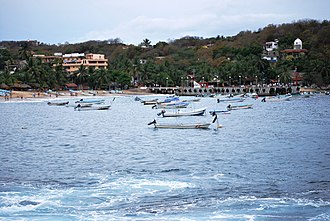
Puerto Ángel is a Mexican port and town in the state of Oaxaca located in the municipality of San Pedro Pochutla. It, along with San Agustinillo and Playa Zipolite are known as the "Riviera Oaxaqueña". It is located 9 km south of city of Pochutla approximately 50 kilometers west of Huatulco and 80 kilometers east of Puerto Escondido. Despite tourism development since the 1960s, the town is still mostly a fishing village, located on a small bay surrounded by rocky hills that lead into the Sierra Madre del Sur. It was founded in the mid-19th century as a port for the region's coffee and lumber industries but since then other means of shipping these products has replaced it.
People
Economy
Climate
| Population | 2,645 |
| Population Density | 163 / sq mi |
| Elevation | 66 ft (20 m) |
| Coordinates | 15.6686°, -96.4918° |
| Timezone | America/Mexico_City |
| Country | 🇲🇽 Mexico |
| State / Province | Oaxaca |
| Average Temperature | 79°F (26°C) |
| January Average | 77°F (25°C) |
| July Average | 80°F (27°C) |
| Annual Precipitation | 42.4 inches (1,077 mm) |
| Annual Snowfall | 0.0 inches (0 cm) |
About Puerto Ángel
Puerto Ángel is a small town in Mexico (Oaxaca) with a population of 2,645. The city sits at an elevation of 66 feet (20 meters) above sea level. The average annual temperature is 79°F (26°C). Temperatures range from 77°F in January to 80°F in July. Annual precipitation averages 42.4 inches. The timezone is America/Mexico_City.
Income: Puerto Ángel vs Mexico
Commute Mode
Income
Employment & Poverty
| Unemployment | 0.9% |
| 75% below Mexico avg | |
| Establishments (County) | 85 |
Business (County)
Tax & Cost of Living
Commute & Transportation
Walkability
Climate in Puerto Ángel
Puerto Ángel has an average annual temperature of 28°C (82°F). The hottest month is May (29°C), the coldest is Jan (26.8°C). Average annual precipitation is 871 mm.
Temperature
| Annual Average | 79.2°F |
| 47% above Mexico avg | |
| January Average | 77°F (25°C) |
| July Average | 80°F (27°C) |
| Sunny Days | 259 days/yr |
Geography
| Elevation | 66 ft (20 m) |
| Area | 16.2 sq mi (42.0 km²) |
| Population Density | 163/sq mi |
| Coordinates | 15.6686°N, 96.4918°W |
| Timezone | America/Mexico_City |
Precipitation & Snow
Air Quality
Tsunami History
6 tsunamis recorded within 500 km. Highest wave on record: 1.6 m (5 ft).
| Year | Location | Cause | Max Wave | Deaths | Distance |
| 2020 | OFF COAST OF OAXACA | Earthquake | 1.6 m | 10 | 57 km |
| 1965 | MEXICO | Earthquake | 0.4 m | 6 | 102 km |
| 2022 | S. MEXICO | Earthquake | 0.2 m | — | 80 km |
| 1928 | S. MEXICO | Earthquake | 0.2 m | 4 | 71 km |
| 1928 | MEXICO | Earthquake | — | — | 42 km |
| 1870 | PUERTO ANGEL, MEXICO | Earthquake | — | 24 | 36 km |
Monthly Weather
| Month | Avg Temperature | Precipitation | Summary |
|---|---|---|---|
| January | 77°F (25°C) | 0.2 in | Coldest, Driest |
| February | 77°F (25°C) | 0.3 in | |
| March | 79°F (26°C) | 0.4 in | |
| April | 81°F (27°C) | 0.8 in | |
| May | 82°F (28°C) | 3.4 in | Warmest |
| June | 81°F (27°C) | 9.3 in | Wettest |
| July | 80°F (27°C) | 6.2 in | |
| August | 80°F (27°C) | 8.2 in | |
| September | 79°F (26°C) | 9.1 in | |
| October | 79°F (26°C) | 3.8 in | |
| November | 79°F (26°C) | 0.7 in | |
| December | 77°F (25°C) | 0.2 in |
Puerto Ángel has a seasonal temperature swing of 5°F / from 77°F in January to 82°F in May. Total annual precipitation is 42.4 inches, with June being the wettest month (9.3") and January the driest (0.2").
Schools in Puerto Ángel
3 public schools (NCES 2022-23 data).
| School | Level | Enrollment | Teachers | Student/Teacher |
|---|---|---|---|---|
| La Escuelita | — | — | — | — |
| Escuela Primaria Lázaro Cárdenas | — | — | — | — |
| Escuela Primaria Lázaro Cárdenas | — | — | — | — |
Libraries in Puerto Ángel
| Name | Address | Staff | Annual Visits | Circulation | Collection | Programs |
|---|---|---|---|---|---|---|
| Biblioteca infantil | 0.0 | |||||
| Biblioteca UMAR | 0.0 | |||||
| La Biblio de Mazunte | 0.0 |
Farmers Markets in Puerto Ángel
| Name | Address | Season | Hours | Organic | Website |
|---|---|---|---|---|---|
| Mercado 12 de Octubre | |||||
| Mercado 12 de Octubre | |||||
| Mercado El Calvario | |||||
| Mercado local de Puerto Ángel |
Hotels in Puerto Ángel
55 hotels within city radius — OpenStreetMap data
Restaurants in Puerto Ángel
64 restaurants within city radius — OpenStreetMap data
Cafes in Puerto Ángel
11 cafes within city radius — OpenStreetMap data
Clinics in Puerto Ángel
1 clinics within city radius — OpenStreetMap data
Veterinaries in Puerto Ángel
1 veterinaries within city radius — OpenStreetMap data
Bus Stations in Puerto Ángel
1 bus stations within city radius — OpenStreetMap data
Gas Stations in Puerto Ángel
2 gas stations within city radius — OpenStreetMap data
Banks in Puerto Ángel
1 banks within city radius — OpenStreetMap data
Gyms in Puerto Ángel
3 gyms within city radius — OpenStreetMap data
Airports Near Puerto Ángel
2 airports within the area.
| Airport | IATA | Type |
|---|---|---|
| Bahías de Huatulco International Airport | HUX | Large Airport |
| Puerto Escondido International Airport | PXM | Medium Airport |
Treatment Centers in Puerto Ángel
1 treatment centers.
| Center | Type | Phone |
|---|---|---|
| Unidad Básica de Rehabilitación |
Churches & Religious Organizations in Puerto Ángel
3 religious organizations (IRS tax-exempt data).
| Name | Address |
|---|---|
| Capilla de Puerto Ángel | |
| Capilla del ángel | |
| Iglesia del Angel |
Quick Facts
🇲🇽 About Mexico
Public Holidays in Mexico
9 public holidays this year
Download Full City Report
Get a comprehensive, print-ready PDF with all data for Puerto Ángel.
Get ReportFrequently Asked Questions About Puerto Ángel
What is the population of Puerto Ángel?
Puerto Ángel has a population of 2,645 residents and is located in Mexico. The population density is 163 people per square mile, spread across 16.2 square miles.
What is the weather like in Puerto Ángel?
Puerto Ángel has a warm climate with an average annual temperature of 79°F (26°C). Winter temperatures average 77°F in January, while summers reach an average of 80°F in July. The area receives 259 sunny days per year, well above the national average of 205. Annual rainfall totals 42.4 inches.
How is the job market in Puerto Ángel?
The job market in Puerto Ángel is very strong, with unemployment at just 0.9% / well below the national rate of 3.6%. There are 85 business establishments in the area.