 All Countries


Samnaun, Switzerland
Grisons · Switzerland
Samnaun is a small town in Grisons, Switzerland with a population of 769. Elevation: 6,040 ft (1,841 m). Average temperature: 34°F (1°C).
Data updated June 2026
Discover Samnaun, Switzerland
Explore over 40 sections covering people, economy, housing, health, crime, climate, community, costs, trends, schools, colleges, hospitals, treatment centers, industries, museums, libraries, breweries, farmers markets, grocery stores, pharmacies, campgrounds, parks, trails, stadiums, ski resorts, daycare centers, nursing homes, churches, fire stations, cell towers, bridges, power plants, EV stations, prisons, radio stations, airports, police stations, post offices, Amtrak stations, superfund sites, UNESCO sites, and more.
Use the tabs and dropdown menus below to navigate every data point we track for this city.
About Samnaun
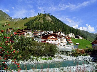
Samnaun is a high Alpine village and a valley at the eastern end of Switzerland and a municipality in the Engiadina Bassa/Val Müstair Region in the Swiss canton of the Grisons.
People
Climate
| Population | 769 |
| Population Density | 0 / sq mi |
| Elevation | 6,040 ft (1,841 m) |
| Coordinates | 46.9437°, 10.3606° |
| Timezone | Europe/Zurich |
| Country | 🇨🇭 Switzerland |
| State / Province | Grisons |
| Average Temperature | 34°F (1°C) |
| January Average | 20°F (-7°C) |
| July Average | 49°F (9°C) |
| Annual Precipitation | 38.0 inches (965 mm) |
| Annual Snowfall | 15.9 inches (40 cm) |
About Samnaun
Samnaun is a small town in Switzerland (Grisons) with a population of 769. The city sits at an elevation of 6,040 feet (1,841 meters) above sea level. The average annual temperature is 34°F (1°C). Temperatures range from 20°F in January to 49°F in July. Annual precipitation averages 38.0 inches. The timezone is Europe/Zurich.
Climate in Samnaun
Samnaun has an average annual temperature of 6.4°C (44°F). The hottest month is Aug (15.4°C), the coldest is Jan (-2.7°C). Average annual precipitation is 458 mm.
Temperature
| Annual Average | 33.9°F |
| 37% below Switzerland avg | |
| January Average | 20°F (-7°C) |
| July Average | 49°F (9°C) |
| Sunny Days | 267 days/yr |
Geography
| Elevation | 6,040 ft (1,841 m) |
| Area | 3,001.6 sq mi (7,774.0 km²) |
| Population Density | 0/sq mi |
| Coordinates | 46.9437°N, 10.3606°W |
| Timezone | Europe/Zurich |
Precipitation & Snow
Air Quality
Tsunami History
3 tsunamis recorded within 500 km. Highest wave on record: 95.0 m (312 ft).
| Year | Location | Cause | Max Wave | Deaths | Distance |
| 1987 | VALTELLINA | Meteorological | 95.0 m | 27 | 63 km |
| 1601 | LAKE LUCERNE | Eruption + Earthquake | 4.0 m | 8 | 142 km |
| 1868 | LAKE GARDA | Earthquake | — | — | 141 km |
Monthly Weather
| Month | Avg Temperature | Precipitation | Summary |
|---|---|---|---|
| January | 20°F (-7°C) | 2.5 in | Coldest |
| February | 20°F (-7°C) | 2.2 in | Driest |
| March | 25°F (-4°C) | 2.7 in | |
| April | 30°F (-1°C) | 2.9 in | |
| May | 39°F (4°C) | 3.3 in | |
| June | 44°F (7°C) | 4.1 in | |
| July | 49°F (9°C) | 4.5 in | Wettest |
| August | 49°F (9°C) | 4.3 in | Warmest |
| September | 44°F (7°C) | 3.2 in | |
| October | 37°F (3°C) | 2.7 in | |
| November | 27°F (-3°C) | 2.8 in | |
| December | 22°F (-5°C) | 2.7 in |
Samnaun has a seasonal temperature swing of 29°F / from 20°F in January to 49°F in August. Total annual precipitation is 38.0 inches, with July being the wettest month (4.5") and February the driest (2.2").
Schools in Samnaun
1 public schools (NCES 2022-23 data).
| School | Level | Enrollment | Teachers | Student/Teacher |
|---|---|---|---|---|
| Schule Samnaun | — | — | — | — |
Museums in Samnaun
| Name | Type | Address | Phone | Annual Revenue |
|---|---|---|---|---|
| Alberto Giacometti Museum | ||||
| Alm Museum | ||||
| Almmuseum | ||||
| Alpinarium Galtür | ||||
| Bienenhaus | ||||
| Festung Nauders | ||||
| Hall Of Fame | ||||
| Heimatmuseum Pfunds | ||||
| Hotel Waldhaus | ||||
| Kunstraum Pettneu | ||||
| Mathias Schmid Museum | ||||
| Museum d'Engiadina Bassa | ||||
| Museum local | ||||
| Museum Schloss Landeck | ||||
| Museum St. Anton | ||||
| Museum Vinschger Oberland - Museo Alta Val Venosta | ||||
| Ora et Labora | ||||
| Paznauner Bauernmuseum | ||||
| Pfarrmuseum Serfaus | ||||
| Pforzheimer Hütte - Rifugio Rasass | ||||
| Schellen-Ursli-Museum | ||||
| Schloss Naudersberg | ||||
| Schmelzra | ||||
| Seilbahnmuseum | ||||
| Talmuseum Samnaun |
Libraries in Samnaun
| Name | Address | Staff | Annual Visits | Circulation | Collection | Programs |
|---|---|---|---|---|---|---|
| Biblioteca cumünala da Ftan | 0.0 | |||||
| Biblioteca cumünala da Sent | 0.0 | |||||
| Biblioteca populara Scuol | 0.0 | |||||
| Bücherei Perjen | 0.0 | |||||
| Bücherei Pettneu | 0.0 | |||||
| Grinner Bibliothek | 0.0 | |||||
| Hüttenbibliothek | 0.0 | |||||
| Mediothek HIF | 0.0 | |||||
| Öffentliche Bibliothek Samnaun-Compatsch | 0.0 | |||||
| Stadtbücherei Landeck | 0.0 |
Hotels in Samnaun
26 hotels within city radius — OpenStreetMap data
Restaurants in Samnaun
18 restaurants within city radius — OpenStreetMap data
Cafes in Samnaun
1 cafes within city radius — OpenStreetMap data
Castles in Samnaun
1 castles within city radius — OpenStreetMap data
Gas Stations in Samnaun
7 gas stations within city radius — OpenStreetMap data
Banks in Samnaun
1 banks within city radius — OpenStreetMap data
Breweries in Samnaun
| Name | Type | Address | Phone | Website |
|---|---|---|---|---|
| Alpenbrauerei Girun | ||||
| Bieraria Tschlin SA |
Stadiums & Teams in Samnaun
| Team | League | Division |
|---|---|---|
Ski Resorts Near Samnaun
129 ski resorts within range.
| Resort | Slopes (km) | Lifts | Peak (m) | Price | Season | Night | Park |
|---|---|---|---|---|---|---|---|
| Ponte di Legno - Passo Tonale | 0.0 | — | — | $0 | — | — | — |
| Valmalenco Bernina | 0.0 | — | — | $0 | — | — | — |
| Folgarida-Marilleva | 0.0 | — | — | $0 | — | — | — |
| Pejo 3000 | 0.0 | — | — | $0 | — | — | — |
| Casaccia | 0.0 | — | — | $0 | — | — | — |
| Aela (Maloja) | 0.0 | — | — | $0 | — | — | — |
| Santa Caterina | 0.0 | — | — | $0 | — | — | — |
| Diavolezza-Lagalb | 0.0 | — | — | $0 | — | — | — |
| Bormio Ski | 0.0 | — | — | $0 | — | — | — |
| Corvatsch-Furtschellas | 0.0 | — | — | $0 | — | — | — |
| Cima Piazzi – San Colombano | 0.0 | — | — | $0 | — | — | — |
| Pontresina | 0.0 | — | — | $0 | — | — | — |
| Sulden am Ortler - Solda al Ortles | 0.0 | — | — | $0 | — | — | — |
| Corviglia | 0.0 | — | — | $0 | — | — | — |
| Passo Stelvio | 0.0 | — | — | $0 | — | — | — |
| Livigno | 0.0 | — | — | $0 | — | — | — |
| Samedan (St. Moritz) | 0.0 | — | — | $0 | — | — | — |
| Schwemmalm | 0.0 | — | — | $0 | — | — | — |
| Trafoi | 0.0 | — | — | $0 | — | — | — |
| Müsella – La Punt | 0.0 | — | — | $0 | — | — | — |
| St. Moritz – Zuoz | 0.0 | — | — | $0 | — | — | — |
| Bergün - Filisur / Darlux | 0.0 | — | — | $0 | — | — | — |
| Minschuns | 0.0 | — | — | $0 | — | — | — |
| Watles - Vatles | 0.0 | — | — | $0 | — | — | — |
| Rinerhorn | 0.0 | — | — | $0 | — | — | — |
| Val Senales-Schnalstal | 0.0 | — | — | $0 | — | — | — |
| Jakobshorn | 0.0 | — | — | $0 | — | — | — |
| Tarasp | 0.0 | — | — | $0 | — | — | — |
| Schöneben - Belpiano | 0.0 | — | — | $0 | — | — | — |
| Schatzalp/Strela (Davos Klosters) | 0.0 | — | — | $0 | — | — | — |
| Pischa | 0.0 | — | — | $0 | — | — | — |
| Bündalift – Davos | 0.0 | — | — | $0 | — | — | — |
| Scuol Motta Naluns | 0.0 | — | — | $0 | — | — | — |
| Parsenn | 0.0 | — | — | $0 | — | — | — |
| Skilift Selfranga | 0.0 | — | — | $0 | — | — | — |
| Vent | 0.0 | — | — | $0 | — | — | — |
| Fideriser Heuberge | 0.0 | — | — | $0 | — | — | — |
| Kaunertaler Gletscher | 0.0 | — | — | $0 | — | — | — |
| Nauders am Reschenpass | 0.0 | — | — | $0 | — | — | — |
| Obergurgl-Hochgurgl | 0.0 | — | — | $0 | — | — | — |
| Madrisa | 0.0 | — | — | $0 | — | — | — |
| Silvretta-Bielerhöhe | 0.0 | — | — | $0 | — | — | — |
| Pitztaler Gletscher | 0.0 | — | — | $0 | — | — | — |
| Pany | 0.0 | — | — | $0 | — | — | — |
| Sölden | 0.0 | — | — | $0 | — | — | — |
| Gargellen | 0.0 | — | — | $0 | — | — | — |
| Rifflsee | 0.0 | — | — | $0 | — | — | — |
| Galtür | 0.0 | — | — | $0 | — | — | — |
| Ischgl-Samnaun | 0.0 | — | — | $0 | — | — | — |
| Junker - St. Antönien | 0.0 | — | — | $0 | — | — | — |
| Übungsgelände Valisera | 0.0 | — | — | $0 | — | — | — |
| Mathon | 0.0 | — | — | $0 | — | — | — |
| Silvretta Montafon | 0.0 | — | — | $0 | — | — | — |
| Fendels | 0.0 | — | — | $0 | — | — | — |
| Serfaus-Fiss-Ladis | 0.0 | — | — | $0 | — | — | — |
| See | 0.0 | — | — | $0 | — | — | — |
| Kappl | 0.0 | — | — | $0 | — | — | — |
| Golm | 0.0 | — | — | $0 | — | — | — |
| Kristberg-Silbertal | 0.0 | — | — | $0 | — | — | — |
| Sonnenkopf | 0.0 | — | — | $0 | — | — | — |
| Brandnertal – Brand/Bürserberg | 0.0 | — | — | $0 | — | — | — |
| Rotecklift / Tobadill | 0.0 | — | — | $0 | — | — | — |
| Venet | 0.0 | — | — | $0 | — | — | — |
| Flirsch | 0.0 | — | — | $0 | — | — | — |
| Hochzeiger | 0.0 | — | — | $0 | — | — | — |
| Tschardund – Nenzing | 0.0 | — | — | $0 | — | — | — |
| Ski Arlberg | 0.0 | — | — | $0 | — | — | — |
| Galtwiesenlift | 0.0 | — | — | $0 | — | — | — |
| Raggal | 0.0 | — | — | $0 | — | — | — |
| Hochoetz | 0.0 | — | — | $0 | — | — | — |
| Hochoetz-Kühtai | 0.0 | — | — | $0 | — | — | — |
| Kühtai | 0.0 | — | — | $0 | — | — | — |
| Sonntag Stein | 0.0 | — | — | $0 | — | — | — |
| Gröllerkopf-Übersaxen | 0.0 | — | — | $0 | — | — | — |
| Gföllberglift | 0.0 | — | — | $0 | — | — | — |
| Bungerloch | 0.0 | — | — | $0 | — | — | — |
| Laterns-Gapfohl | 0.0 | — | — | $0 | — | — | — |
| Jöchelspitze | 0.0 | — | — | $0 | — | — | — |
| Zwergberg Furx | 0.0 | — | — | $0 | — | — | — |
| Furx | 0.0 | — | — | $0 | — | — | — |
| Knittellifte | 0.0 | — | — | $0 | — | — | — |
| Diedamskopf | 0.0 | — | — | $0 | — | — | — |
| Tallifte | 0.0 | — | — | $0 | — | — | — |
| Ski lift Schwärzenbach | 0.0 | — | — | $0 | — | — | — |
| Heuberg Arena/Walmendingerhorn | 0.0 | — | — | $0 | — | — | — |
| Heumöserlift | 0.0 | — | — | $0 | — | — | — |
| Fellhorn/Kanzelwand | 0.0 | — | — | $0 | — | — | — |
| Ifen | 0.0 | — | — | $0 | — | — | — |
| Biberwier - Marienberg | 0.0 | — | — | $0 | — | — | — |
| Kleinwalsertal-Oberstdorf | 0.0 | — | — | $0 | — | — | — |
| Heini-Klopfer-Skiflugschanze | 0.0 | — | — | $0 | — | — | — |
| Familienskipark Stanzach | 0.0 | — | — | $0 | — | — | — |
| Ehrwalder Almbahn | 0.0 | — | — | $0 | — | — | — |
| Nordic Zentrum Oberstdorf | 0.0 | — | — | $0 | — | — | — |
| Söllereck | 0.0 | — | — | $0 | — | — | — |
| Lermoos - Grubigstein | 0.0 | — | — | $0 | — | — | — |
| Niedere Andelsbuch-Bezau | 0.0 | — | — | $0 | — | — | — |
| Orlen Arena Oberstdorf Allgäu | 0.0 | — | — | $0 | — | — | — |
| Bödele | 0.0 | — | — | $0 | — | — | — |
| Ehrwald Wettersteinbahnen | 0.0 | — | — | $0 | — | — | — |
| Nebelhorn | 0.0 | — | — | $0 | — | — | — |
| Schetteregg | 0.0 | — | — | $0 | — | — | — |
| Berwang | 0.0 | — | — | $0 | — | — | — |
| Ski resort Zugspitze | 0.0 | — | — | $0 | — | — | — |
| Balderschwang – Hochschelpen/Riedberger Horn | 0.0 | — | — | $0 | — | — | — |
| Hörnerbahn Bolsterlang | 0.0 | — | — | $0 | — | — | — |
| Skiweltcup Garmisch-Kandahar Rennen | 0.0 | — | — | $0 | — | — | — |
| Schollenwiesenlift Höfen | 0.0 | — | — | $0 | — | — | — |
| Hahnenkamm Höfen | 0.0 | — | — | $0 | — | — | — |
| Hochhäderich | 0.0 | — | — | $0 | — | — | — |
| Tannheim-Zöblen-Schattwald | 0.0 | — | — | $0 | — | — | — |
| Pfänder | 0.0 | — | — | $0 | — | — | — |
| Ofterschwang/Gunzesried | 0.0 | — | — | $0 | — | — | — |
| Hochlitten-Riefensberg | 0.0 | — | — | $0 | — | — | — |
| Füssener Jöchle-Grän | 0.0 | — | — | $0 | — | — | — |
| Hindelang Oberjoch | 0.0 | — | — | $0 | — | — | — |
| Hagenberg Sulzberg-Thal | 0.0 | — | — | $0 | — | — | — |
| Spieserlifte | 0.0 | — | — | $0 | — | — | — |
| Hinterstaufen | 0.0 | — | — | $0 | — | — | — |
| Immenstadt | 0.0 | — | — | $0 | — | — | — |
| Skizentrum Pfronten | 0.0 | — | — | $0 | — | — | — |
| Nachwuchsförderzentrum "Reithlift" | 0.0 | — | — | $0 | — | — | — |
| Skilifte Thaler Höhe | 0.0 | — | — | $0 | — | — | — |
| Sonnenlifte Röfleuten/Halden | 0.0 | — | — | $0 | — | — | — |
| Buron | 0.0 | — | — | $0 | — | — | — |
| Nesselwang - Alpspitzbahnen | 0.0 | — | — | $0 | — | — | — |
| Steckenberg | 0.0 | — | — | $0 | — | — | — |
| Ellegglifte – Faistenoy | 0.0 | — | — | $0 | — | — | — |
| Iberg | 0.0 | — | — | $0 | — | — | — |
Airports Near Samnaun
9 airports within the area.
| Airport | IATA | Type |
|---|---|---|
| Engadin Airport | SMV | Medium Airport |
| Agathazell Airfield | — | Small Airport |
| Füssen Glider Airfield | — | Small Airport |
| Hohenems-Dornbirn Airfield | HOH | Small Airport |
| Kempten-Durach Airfield | — | Small Airport |
| Passo del Tonale Airfield | — | Small Airport |
| Reutte-Höfen Airfield | — | Small Airport |
| Termon Altiport | — | Small Airport |
| Wildberg Airfield | — | Small Airport |
Churches & Religious Organizations in Samnaun
3 religious organizations (IRS tax-exempt data).
| Name | Address |
|---|---|
| Kapelle Ravaisch | |
| Maria Hilf chapel | |
| Pfarrkirche St. Jakob |
Quick Facts
🇨🇭 About Switzerland
Public Holidays in Switzerland
23 public holidays this year
Download Full City Report
Get a comprehensive, print-ready PDF with all data for Samnaun.
Get ReportFrequently Asked Questions About Samnaun
What is the population of Samnaun?
Samnaun has a population of 769 residents and is located in Switzerland. The population density is 0 people per square mile, spread across 3,001.6 square miles.
What is the weather like in Samnaun?
Samnaun has a cool climate with an average annual temperature of 34°F (1°C). Winter temperatures average 20°F in January, while summers reach an average of 49°F in July. The area receives 267 sunny days per year, well above the national average of 205. Annual rainfall totals 38.0 inches, with 15.9 inches of snow.