 All Countries


Taputimu, American Samoa
Western District · American Samoa
Taputimu is a small town in Western District, American Samoa with a population of 741. Elevation: 105 ft (32 m). Average temperature: 81°F (27°C).
Data updated June 2026
Discover Taputimu, American Samoa
Explore over 40 sections covering people, economy, housing, health, crime, climate, community, costs, trends, schools, colleges, hospitals, treatment centers, industries, museums, libraries, breweries, farmers markets, grocery stores, pharmacies, campgrounds, parks, trails, stadiums, ski resorts, daycare centers, nursing homes, churches, fire stations, cell towers, bridges, power plants, EV stations, prisons, radio stations, airports, police stations, post offices, Amtrak stations, superfund sites, UNESCO sites, and more.
Use the tabs and dropdown menus below to navigate every data point we track for this city.
About Taputimu
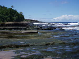
Taputimu is a village in southwestern Tutuila Island in American Samoa. It is the nearest village to the Fagatele Bay National Marine Sanctuary, although the main access is from the neighboring village of Futiga. It is home to Leala Shoreline National Natural Landmark and Leala Sliding Rock. Leala Sliding Rock is a natural rock formation between Vailoatai and Taputimu, which is a scenic landmark as well as a natural playground or slide. It was created by the ebb and flow of the ocean; the erosion has created a smooth shoreline site. It is located in Tualatai County in the Western District of Tutuila.
People
Climate
| Population | 741 |
| Population Density | 2,117 / sq mi |
| Elevation | 105 ft (32 m) |
| Coordinates | -14.3603°, -170.7731° |
| Timezone | Pacific/Pago_Pago |
| Country | 🇦🇸 American Samoa |
| State / Province | Western District |
| Average Temperature | 81°F (27°C) |
| January Average | 81°F (27°C) |
| July Average | 81°F (27°C) |
| Annual Precipitation | 114.4 inches (2,905 mm) |
| Annual Snowfall | 0.0 inches (0 cm) |
About Taputimu
Taputimu is a small town in American Samoa (Western District) with a population of 741. The city sits at an elevation of 105 feet (32 meters) above sea level. The average annual temperature is 81°F (27°C). Temperatures range from 81°F in January to 81°F in July. Annual precipitation averages 114.4 inches. The timezone is Pacific/Pago_Pago.
Climate in Taputimu
Taputimu has an average annual temperature of 27.9°C (82°F). The hottest month is Jan (28.4°C), the coldest is Aug (27.1°C). Average annual precipitation is 3228 mm.
Temperature
| Annual Average | 81.0°F |
| 50% above American Samoa avg | |
| January Average | 81°F (27°C) |
| July Average | 81°F (27°C) |
| Sunny Days | 332 days/yr |
Geography
| Elevation | 105 ft (32 m) |
| Area | 0.4 sq mi (0.9 km²) |
| Population Density | 2,117/sq mi |
| Coordinates | -14.3603°N, 170.7731°W |
| Timezone | Pacific/Pago_Pago |
Precipitation & Snow
Air Quality
Nearby Volcanoes
5 volcanoes within 200 km. Closest: Tutuila (11 km).
| Name | Type | Elevation | Last Eruption | Distance |
| Tutuila | Tuff cone(s) | 653 m (2,142 ft) | 440 | 11 km |
| Upolu | Shield | 1,100 m (3,609 ft) | Unknown | 113 km |
| Ofu-Olosega | Shield(s) | 639 m (2,096 ft) | 1866 | 126 km |
| Ta'u | Shield | 931 m (3,054 ft) | Unknown | 143 km |
| Vailulu'u | Submarine | -592 m (-1,942 ft) | 2003 | 186 km |
Monthly Weather
| Month | Avg Temperature | Precipitation | Summary |
|---|---|---|---|
| January | 81°F (27°C) | 16.8 in | Wettest |
| February | 81°F (27°C) | 13.9 in | |
| March | 81°F (27°C) | 14.0 in | Warmest |
| April | 81°F (27°C) | 10.5 in | |
| May | 80°F (27°C) | 9.5 in | |
| June | 80°F (27°C) | 6.5 in | Driest |
| July | 81°F (27°C) | 7.4 in | |
| August | 79°F (26°C) | 7.1 in | Coldest |
| September | 80°F (26°C) | 7.7 in | |
| October | 80°F (27°C) | 12.3 in | |
| November | 80°F (27°C) | 10.2 in | |
| December | 81°F (27°C) | 15.9 in |
Taputimu has a seasonal temperature swing of 3°F / from 79°F in August to 81°F in March. Total annual precipitation is 131.8 inches, with January being the wettest month (16.8") and June the driest (6.5").
Museums in Taputimu
| Name | Type | Address | Phone | Annual Revenue |
|---|---|---|---|---|
| Jean P. Haydon Museum | ||||
| National Park of American Samoa | ||||
| Tauese P.F. Sunia Ocean Center |
Libraries in Taputimu
| Name | Address | Staff | Annual Visits | Circulation | Collection | Programs |
|---|---|---|---|---|---|---|
| Feleti Barstow Public Library | 0.0 | |||||
| Library of American Samoa | 0.0 |
Farmers Markets in Taputimu
| Name | Address | Season | Hours | Organic | Website |
|---|---|---|---|---|---|
| Fagatogo Market |
Stadiums & Teams in Taputimu
| Team | League | Division |
|---|---|---|
Superfund Sites Near Taputimu
1 EPA Superfund sites (hazardous waste cleanup locations).
| Site | Address | County |
|---|---|---|
| STARKIST SAMOA INC | MAIN ROAD | EASTERN |
Airports Near Taputimu
1 airports within the area.
| Airport | IATA | Type |
|---|---|---|
| Pago Pago International Airport | PPG | Large Airport |
Quick Facts
🇦🇸 About American Samoa
Download Full City Report
Get a comprehensive, print-ready PDF with all data for Taputimu.
Get ReportFrequently Asked Questions About Taputimu
What is the population of Taputimu?
Taputimu has a population of 741 residents and is located in American Samoa. The population density is 2,117 people per square mile, spread across 0.4 square miles.
What is the weather like in Taputimu?
Taputimu has a warm climate with an average annual temperature of 81°F (27°C). Winter temperatures average 81°F in January, while summers reach an average of 81°F in July. The area receives 332 sunny days per year, well above the national average of 205. Annual rainfall totals 114.4 inches.