 All Countries


Xochipala, Mexico
Guerrero · Mexico
Xochipala is a small town in Guerrero, Mexico with a population of 3,620. Elevation: 3,510 ft (1,070 m). Average temperature: 77°F (25°C).
Discover Xochipala, Mexico
Explore over 40 sections covering people, economy, housing, health, crime, climate, community, costs, trends, schools, colleges, hospitals, treatment centers, industries, museums, libraries, breweries, farmers markets, grocery stores, pharmacies, campgrounds, parks, trails, stadiums, ski resorts, daycare centers, nursing homes, churches, fire stations, cell towers, bridges, power plants, EV stations, prisons, radio stations, airports, police stations, post offices, Amtrak stations, superfund sites, UNESCO sites, and more.
Use the tabs and dropdown menus below to navigate every data point we track for this city.
About Xochipala
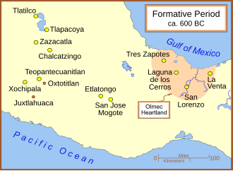
Xochipala is a minor archaeological site in the Mexican state of Guerrero, whose name has become attached, somewhat erroneously, to a style of Formative Period figurines and pottery from 1500 to 200 BCE. The archaeological site is much later and belongs to the Classic and Postclassic eras, approximately 200–1400 CE.
People
Economy
Climate
| Population | 3,620 |
| Population Density | 11 / sq mi |
| Elevation | 3,510 ft (1,070 m) |
| Coordinates | 17.8118°, -99.6398° |
| Timezone | America/Mexico_City |
| Country | 🇲🇽 Mexico |
| State / Province | Guerrero |
| Average Temperature | 77°F (25°C) |
| January Average | 73°F (23°C) |
| July Average | 77°F (25°C) |
| Annual Precipitation | 38.4 inches (975 mm) |
| Annual Snowfall | 0.0 inches (0 cm) |
About Xochipala
Xochipala is a small town in Mexico (Guerrero) with a population of 3,620. The city sits at an elevation of 3,510 feet (1,070 meters) above sea level. The average annual temperature is 77°F (25°C). Temperatures range from 73°F in January to 77°F in July. Annual precipitation averages 38.4 inches. The timezone is America/Mexico_City.
Income: Xochipala vs Mexico
Commute Mode
Income
Employment & Poverty
| Unemployment | 1.7% |
| 53% below Mexico avg | |
| Establishments (County) | 116 |
Business (County)
Tax & Cost of Living
Commute & Transportation
Walkability
Temperature
| Annual Average | 76.6°F |
| 42% above Mexico avg | |
| January Average | 73°F (23°C) |
| July Average | 77°F (25°C) |
| Sunny Days | 266 days/yr |
Geography
| Elevation | 3,510 ft (1,070 m) |
| Area | 339.0 sq mi (878.1 km²) |
| Population Density | 11/sq mi |
| Coordinates | 17.8118°N, 99.6398°W |
| Timezone | America/Mexico_City |
Precipitation & Snow
Air Quality
Tsunami History
13 tsunamis recorded within 500 km. Highest wave on record: 4.0 m (13 ft).
| Year | Location | Cause | Max Wave | Deaths | Distance |
| 1820 | S. MEXICO | Earthquake | 4.0 m | — | 68 km |
| 1754 | S. MEXICO | Earthquake | 4.0 m | — | 122 km |
| 1732 | S. MEXICO | Earthquake | 3.0 m | — | 116 km |
| 1907 | S. MEXICO | Earthquake | 2.0 m | 8 | 98 km |
| 1962 | S. MEXICO | Earthquake | 0.8 m | 4 | 68 km |
| 2021 | S. MEXICO | Earthquake | 0.5 m | 3 | 93 km |
| 2014 | S. MEXICO | Earthquake | 0.4 m | — | 149 km |
| 1962 | S. MEXICO | Earthquake | 0.3 m | 3 | 70 km |
| 2026 | ACAPULCO | Earthquake | 0.1 m | 2 | 107 km |
| 1933 | MEXICO | Earthquake | — | — | 142 km |
| 1868 | S. MEXICO | Earthquake | — | — | 116 km |
| 1845 | S. MEXICO | Earthquake | — | — | 136 km |
| 1833 | S. MEXICO | Earthquake | — | — | 116 km |
Nearby Volcanoes
6 volcanoes within 200 km. Closest: Toluca, Nevado de (145 km).
| Name | Type | Elevation | Last Eruption | Distance |
| Toluca, Nevado de | Stratovolcano | 4,680 m (15,354 ft) | -1350 | 145 km |
| Chichinautzin | Volcanic field | 3,930 m (12,894 ft) | 400 | 151 km |
| Popocatepetl | Stratovolcano(es) | 5,393 m (17,694 ft) | 2020 | 172 km |
| Iztaccihuatl | Stratovolcano | 5,230 m (17,159 ft) | Unknown | 185 km |
| Zitacuaro-Valle de Bravo | Caldera | 3,500 m (11,483 ft) | -3050 | 188 km |
| Papayo | Lava dome | 3,600 m (11,811 ft) | Unknown | 194 km |
Monthly Weather
| Month | Avg Temperature | Precipitation | Summary |
|---|---|---|---|
| January | 73°F (23°C) | 0.4 in | Coldest |
| February | 75°F (24°C) | 0.1 in | Driest |
| March | 78°F (26°C) | 0.1 in | |
| April | 81°F (27°C) | 0.4 in | |
| May | 81°F (27°C) | 2.0 in | Warmest |
| June | 79°F (26°C) | 7.5 in | |
| July | 77°F (25°C) | 8.0 in | Wettest |
| August | 77°F (25°C) | 8.0 in | |
| September | 76°F (24°C) | 8.0 in | |
| October | 76°F (24°C) | 3.1 in | |
| November | 74°F (24°C) | 0.6 in | |
| December | 73°F (23°C) | 0.2 in |
Xochipala has a seasonal temperature swing of 9°F / from 73°F in January to 81°F in May. Total annual precipitation is 38.4 inches, with July being the wettest month (8.0") and February the driest (0.1").
Radio Stations near Xochipala
3 stations within ~55 km.
| Station | Genre | Quality | |
|---|---|---|---|
| LA BESTIA GRUPERA 99.7 (Chilpancingo) - 99.7 FM - XHEPI-FM - Grupo Audiorama Comunicaciones - Chilpancingo, Guerrero | 99.7 fm, américa | AAC+ 23 kbps | |
| DSS RADIO 107.9 (Chilpancingo) - 107.9 FM - XHSCAS-FM - Digital con Sentido Social 106.3, A.C. - Chilpancingo, Guerrero | 107.9 fm, américa | MP3 320 kbps | |
| W RADIO 105.1 (Chilpancingo) - 105.1 FM - XHEZUM-FM - Grupo Radio Cañón - Chilpancingo, Guerrero | 105.1 fm, américa | MP3 128 kbps |
Airports Near Xochipala
3 airports within the area.
| Airport | IATA | Type |
|---|---|---|
| Aeródromo Los Filos | — | Small Airport |
| Aeródromo Zacacoyuca | — | Small Airport |
| Chilpancingo National Airport | — | Small Airport |
Churches & Religious Organizations in Xochipala
1 religious organizations (IRS tax-exempt data).
| Name | Address |
|---|---|
| Iglesia de San Martín de Porres |
Quick Facts
🇲🇽 About Mexico
Public Holidays in Mexico
9 public holidays this year
Download Full City Report
Get a comprehensive, print-ready PDF with all data for Xochipala.
Get ReportFrequently Asked Questions About Xochipala
What is the population of Xochipala?
Xochipala has a population of 3,620 residents and is located in Mexico. The population density is 11 people per square mile, spread across 339.0 square miles.
What is the weather like in Xochipala?
Xochipala has a warm climate with an average annual temperature of 77°F (25°C). Winter temperatures average 73°F in January, while summers reach an average of 77°F in July. The area receives 266 sunny days per year, well above the national average of 205. Annual rainfall totals 38.4 inches.
How is the job market in Xochipala?
The job market in Xochipala is very strong, with unemployment at just 1.7% / well below the national rate of 3.6%. There are 116 business establishments in the area.